Równik


Równik – część wspólna powierzchni ciała niebieskiego oraz płaszczyzny prostopadłej do osi obrotu i przechodzącej przez środek masy ciała.
Równik Ziemi jest w przybliżeniu okręgiem wielkim kuli ziemskiej. Jest też jej najdłuższym równoleżnikiem. Jego szerokość geograficzna wynosi 0°.
Równik kuli ziemskiej
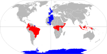
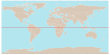
Równik kuli ziemskiej dzieli ją na dwie półkule: północną i południową, a jego długość wynosi 40 075 kilometrów.
| Lp. | Państwo | Uwagi |
|---|---|---|
| 1 | Przechodzi przez wyspę Ilhéu das Rolas. | |
| 2 | Przechodzi przez przynależne terytorium morskie[1][2][3]. | |
| 3 | ||
| 4 | ||
| 5 | ||
| 6 | ||
| 7 | ||
| 8 | ||
| 9 | Przechodzi przez przynależne terytorium morskie. | |
| 10 | ||
| 11 | Przechodzi przez przynależne terytorium morskie. | |
| 12 | Przechodzi przez przynależne terytorium morskie wyspy Baker. | |
| 13 | ||
| 14 | ||
| 15 |
Zobacz też
Przypisy
Media użyte na tej stronie
Flag of São Tomé and Príncipe
The national flag of the Democratic Republic of the Congo. Created according to the 2006 constitution : Son emblème est le drapeau bleu ciel, orné d’une étoile jaune dans le coin supérieur gauche et traversé en biais d’une bande rouge finement encadrée de jaune. (Its symbol is a sky blue flag, decorated with a yellow star in the upper left corner and crossed in the diagonal by a red strip with thin yellow borders) It seems to be identical, except for a lighter field hue, to the 1966–1971 flag.
Flag of Maldives. The colours used are Pantone 186 C for red and Pantone 348 C for green.
bendera Indonesia
The flag of Navassa Island is simply the United States flag. It does not have a "local" flag or "unofficial" flag; it is an uninhabited island. The version with a profile view was based on Flags of the World and as a fictional design has no status warranting a place on any Wiki. It was made up by a random person with no connection to the island, it has never flown on the island, and it has never received any sort of recognition or validation by any authority. The person quoted on that page has no authority to bestow a flag, "unofficial" or otherwise, on the island.
Made by author of Xramp, first uploaded by Denelson83 as Flag of Ecuador.svg, modifications by Husunqu.
Autor: taken by Husond, Licencja: Copyrighted free use
picture taken by Husond's sister. She releases it for free distribution, no rights reserved.
Autor: Thesevenseas (talk), Licencja: CC BY-SA 3.0
World map with equator in SVG format. Based on World.svg.


