Röke

Röke
ilustracja
Państwo Szwecja
RegionSkania
GminaHässleholm
Powierzchnia0,79[1] km²
Populacja (2018)
• liczba ludności
• gęstość

207[1]
262[1] os./km²
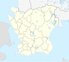
Położenie na mapie Skanii
Mapa konturowa Skanii, u góry znajduje się punkt z opisem „Röke”
Położenie na mapie Szwecji
Mapa konturowa Szwecji, blisko dolnej krawiędzi po lewej znajduje się punkt z opisem „Röke”
56,241944°N 13,527573°E/56,241944 13,527573
Portal Szwecja

Röke – miejscowość (tätort) w Szwecji, w regionie administracyjnym (län) Skania, w gminie Hässleholm.

Według danych Szwedzkiego Urzędu Statystycznego liczba ludności wyniosła: 204 (31 grudnia 2015), 207 (31 grudnia 2018) i 196 (31 grudnia 2019)[1].

Przypisy

  1. a b c d Statistiska tätorter 2018; befolkning, landareal, befolkningstäthet (szw.). Statistikmyndigheten SCB, 2020-03-20. [dostęp 2020-09-08]. [zarchiwizowane z tego adresu (2020-03-24)].

Media użyte na tej stronie

Sweden location map.svg
Autor: NordNordWest, Licencja: CC BY-SA 3.0
Location map of Sweden
Röke kyrka 7, juli 2021.jpg
Autor:

This image was produced by me, David Castor (user:dcastor). The pictures I submit to the Wikipedia Project are released to the public domain. This gives you the right to use them in any way you like, without any kind of notification. This said, I would still appreciate to be mentioned as the originator whenever you think it complies well with your use of the picture. A message to me about how it has been used would also be welcome. You are obviously not required to respond to these wishes of mine, just in a friendly manner encouraged to. (All my photos are placed in Category:Images by David Castor or a subcategory thereof.)

David Castor Wikimedia.jpg

, Licencja: CC0
in the RAÄ buildings database.
Sweden Scania location map.svg
Autor: Erik Frohne, Licencja: CC BY 3.0
Location map of Scania (Skåne) in Sweden

Equirectangular projection, N/S stretching 179 %. Geographic limits of the map:

  • N: 56° 37' N
  • S: 55° 12' N
  • W: 12° 12' E
  • E: 15° 00' E