Rajkot
 | |||
| |||
| Państwo | |||
|---|---|---|---|
| Stan | |||
| Region | Saurashtra | ||
| Dystrykt | Rajkot | ||
| Burmistrz | Sandhya Vyas | ||
| Powierzchnia | 104,86 km² | ||
| Wysokość | 134 m n.p.m. | ||
| Populacja (2008) • liczba ludności • gęstość |
| ||
| Nr kierunkowy | 281 | ||
| Kod pocztowy | 360001 | ||
| Tablice rejestracyjne | GJ3 | ||
Położenie na mapie Indii | |||
| Strona internetowa | |||
Rajkot (hindi राजकोट = Radźkot, gudźarati: રાજકોટ) – miasto w zachodnich Indiach, w stanie Gudźarat, w środkowej części półwyspu Kathijawar. Około 1,25 mln mieszkańców.
Miasta partnerskie
Media użyte na tej stronie
(c) Uwe Dedering z niemieckiej Wikipedii, CC BY-SA 3.0
Location map of India.
Equirectangular projection. Strechted by 106.0%. Geographic limits of the map:
- N: 37.5° N
- S: 5.0° N
- W: 67.0° E
- E: 99.0° E
The Flag of India. The colours are saffron, white and green. The navy blue wheel in the center of the flag has a diameter approximately the width of the white band and is called Ashoka's Dharma Chakra, with 24 spokes (after Ashoka, the Great). Each spoke depicts one hour of the day, portraying the prevalence of righteousness all 24 hours of it.
Autor: Jadia gaurang, Licencja: CC BY 3.0
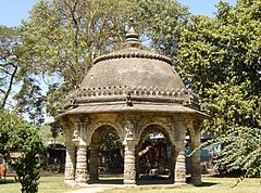
Bandstand in the Queen Victoria memorial institute buildings located in Jubilee Garden, Rajkot.
Flag of Rajkot Principality until 1948
Flag status and standard of the Thakur sahib (Sovereign) dating back to a date not known and in until 1948. Scaling about 3/5. The dark blue cloth, through an unusual yellow cross of St. Andrew and centrally grand showed the emblem of the prince, without the colors. The moon, Chandra appeared together antelope, who rode when he was on earth. On sickle moon, written રંજે ધર્મી પ્રજા રાજા in Gujarati, which means "gifts from heaven to the people of regime". On both sides, two tridenti of Siva and the top Katar, a rajputa weapon, alludes to the sovereign.
Autor: Maximilian Dörrbecker (Chumwa), Licencja: CC BY-SA 3.0
Location map of Gujarat


