Ralik Chain
| Państwo | |
|---|---|
| Akwen | Ocean Spokojny |
| Mapa | |
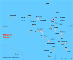
Ralik Chain[1] (pol. „zachód słońca, zachód”[2]) – jeden z dwóch łańcuchów wysp i atoli państwa wyspiarskiego Wysp Marshalla na Oceanie Spokojnym; drugim łańcuchem jest Ratak Chain[1] (pol. „wschód słońca, wschód”[2]).
Położony na zachodzie Wysp Marshall łańcuch obejmuje trzy wyspy: Jabwot, Kili i Lib oraz 15 atoli[3][4]:
| Numer | Zdjęcie | Nazwa atolu[1] | Liczba wysepek | Powierzchnia lądu km² | Powierzchnia laguny km² | Opis |
|---|---|---|---|---|---|---|
| 1 |  | Ailinginae | 25[5] | 2,80[5] | 105,96[5] | Niezamieszkany[3] |
| 2 |  | Ailinglapalap | 52[6] | 14,69[6] | 750,29[6] | |
| 3 | 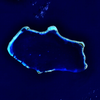 | Bikini | 36[7] | 6,01[7] | 594,14[7] | Miejsce prowadzenia przez Stany Zjednoczone prób z bronią jądrową[3]. W 2010 roku atol Bikini – miejsce prób jądrowych został wpisany na listę światowego dziedzictwa UNESCO[8]. |
| 4 |  | Ebon | 22[9] | 5,75[9] | 103,83[9] | |
| 5 | 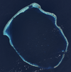 | Enewetak | 40[10] | 5,85[10] | 1004,89[10] | Miejsce prowadzenia przez Stany Zjednoczone prób z bronią jądrową[3]. Pierwsza w historii detonacja bomby wodorowej – bomby nazwanej Ivy Mike – zniszczyła doszczętnie wysepkę Elugelab[11]. |
| 6 |  | Jaluit | 84[12] | 11,34[12] | 689,74[12] | |
| 7 |  | Kwajalein | 93[13] | 16,39[13] | 2173,78[13] | Największy pod względem zajmowanej powierzchni atol na świecie[3]. |
| 8 |  | Lae | 17[14] | 1,45[14] | 17,66[14] | |
| 9 |  | Namorik | 2[15] | 2,77[15] | 8,42[15] | |
| 10 |  | Namu | 51[16] | 6,27[16] | 397,64[16] | |
| 11 |  | Rongelap | 61[17] | 7,95[17] | 1004,32[17] | |
| 12 |  | Rongerik | 17[18] | 1,68[18] | 143,95[18] | Niezamieszkany[3] |
| 13 |  | Ujae | 14[19] | 1,86[19] | 185,94[19] | |
| 14 |  | Ujelang | 32[20] | 1,74[20] | 65,97[20] | |
| 15 |  | Wotho | 13[21] | 4,33[21] | 94,92[21] |
Historia
Niewiele wiadomo na temat historii Wysp Marshalla przed przybyciem Europejczyków[22]. Hiszpanie odwiedzali wyspy wielokrotnie w latach 1522–1568[22]. W 1528 roku hiszpański żeglarz Álvaro de Saavedra Cerón (zm. 1529) odkrył atole Ailinginae i Rongelap, a w 1529 roku Enewetak i Ujelang[23]. W 1543 roku hiszpański podróżnik Ruy López de Villalobos (1500–1544) odkrył atole Kwajalein, Lea, Ujale i Wotho[23]. W 1568 roku hiszpański żeglarz Álvaro de Mendaña de Neyra (1541–1595) odkrył atol Namu[24].
W 1767 roku angielski oficer brytyjskiej marynarki Royal Navy Samuel Wallis (1728–1795) odkrył atol Rongerik[23].
W 1817 roku rosyjski podróżnik i odkrywca Otto von Kotzebue (1788–1846) dotarł do archipelagów Ratak i Ralik na pokładzie statku Rurik[22]. W 1825 roku Kotzebue odkrył atol Bikini[23].
Po II wojnie światowej Stany Zjednoczone przeprowadziły serie prób z bronią jądrową na atolach Bikini (Operacja Crossroads, 1946) i Enewetak (Operacja Ivy, 1952)[11].
Przypisy
- ↑ a b c Nazewnictwo Geograficzne Świata. Zeszyt 1. Komisja Standaryzacji Nazw Geograficznych, 2004, s. 143. ISBN 83-239-7552-3. (pol.)
- ↑ a b Anono Lieom Loeak, Veronica C. Kiluwe, Linda Crowl: Life in the Republic of the Marshall Islands. University of South Pacific Centre Majuro and Institute of Pacific Studies Univeristy of the South Pacific, s. 241. ISBN 978-982-02-0364-8. [dostęp 2016-07-30].
- ↑ a b c d e f Earl R. Hinz, Jim Howard: Landfalls of Paradise: Cruising Guide to the Pacific Islands. University of Hawaii Press, 2006, s. 292. ISBN 978-0-8248-3037-3. [dostęp 2016-07-30].
- ↑ Moshe Rapaport: The Pacific Islands: Environment & Society. Bess Press, 1999, s. 421-426. ISBN 978-1-57306-042-4. [dostęp 2016-07-30].
- ↑ a b c Digital Micronesia-An Electronic Library & Archive is: Marshall Islands Atoll Information Ailinginae Atoll (ang.). [dostęp 2016-07-31].
- ↑ a b c Digital Micronesia-An Electronic Library & Archive is: Marshall Islands Atoll Information Ailinglaplap Atoll (ang.). [dostęp 2016-07-31].
- ↑ a b c Digital Micronesia-An Electronic Library & Archive is: Marshall Islands Atoll Information Bikini (ang.). [dostęp 2016-07-31].
- ↑ UNESCO: Bikini Atoll Nuclear Test Site (ang.). [dostęp 2016-08-01].
- ↑ a b c Digital Micronesia-An Electronic Library & Archive is: Marshall Islands Atoll Information Ebon Atoll (ang.). [dostęp 2016-07-31].
- ↑ a b c Digital Micronesia-An Electronic Library & Archive is: Marshall Islands Atoll Information Enewetak Atoll (ang.). [dostęp 2016-07-31].
- ↑ a b Peter O. K. Krehl: History of Shock Waves, Explosions and Impact: A Chronological and Biographical Reference. Springer Science & Business Media, 2008, s. 593. ISBN 978-3-540-30421-0. [dostęp 2016-07-31]. (ang.)
- ↑ a b c Digital Micronesia-An Electronic Library & Archive is: Marshall Islands Atoll Information Jaluit Atoll (ang.). [dostęp 2016-07-31].
- ↑ a b c Digital Micronesia-An Electronic Library & Archive is: Marshall Islands Atoll Information Kwajalein Atoll (ang.). [dostęp 2016-07-31].
- ↑ a b c Digital Micronesia-An Electronic Library & Archive is: Marshall Islands Atoll Information Lae Atoll (ang.). [dostęp 2016-07-31].
- ↑ a b c Digital Micronesia-An Electronic Library & Archive is: Marshall Islands Atoll Information Namorik Atoll (ang.). [dostęp 2016-07-31].
- ↑ a b c Digital Micronesia-An Electronic Library & Archive is: Marshall Islands Atoll Information Namu Atoll (ang.). [dostęp 2016-07-31].
- ↑ a b c Digital Micronesia-An Electronic Library & Archive is: Marshall Islands Atoll Information Ronglap Atoll (ang.). [dostęp 2016-07-31].
- ↑ a b c Digital Micronesia-An Electronic Library & Archive is: Marshall Islands Atoll Information Rongerik Atoll (ang.). [dostęp 2016-07-31].
- ↑ a b c Digital Micronesia-An Electronic Library & Archive is: Marshall Islands Atoll Information Ujae Atoll (ang.). [dostęp 2016-07-31].
- ↑ a b c Digital Micronesia-An Electronic Library & Archive is: Marshall Islands Atoll Information Ujelang Atoll (ang.). [dostęp 2016-07-31].
- ↑ a b c Digital Micronesia-An Electronic Library & Archive is: Marshall Islands Atoll Information Wotho Atoll (ang.). [dostęp 2016-07-31].
- ↑ a b c Anono Lieom Loeak, Veronica C. Kiluwe, Linda Crowl: Life in the Republic of the Marshall Islands. University of South Pacific Centre Majuro and Institute of Pacific Studies Univeristy of the South Pacific, s. 192. ISBN 978-982-02-0364-8. [dostęp 2016-07-30].
- ↑ a b c d Max Quanchi, John Robson: Historical Dictionary of the Discovery and Exploration of the Pacific Islands. Lanham, Maryland; Toronto; Oxford: The Scarecrow Press, Inc., 2016-08-01, s. XX. ISBN 0-8108-5395-7. (ang.)
- ↑ Max Quanchi, John Robson: Historical Dictionary of the Discovery and Exploration of the Pacific Islands. Lanham, Maryland; Toronto; Oxford: The Scarecrow Press, Inc., 2016-08-01, s. XIX. ISBN 0-8108-5395-7. (ang.)
Media użyte na tej stronie
Autor: Uwe Dedering, Licencja: CC BY-SA 3.0
Relief location map of Pacific_Ocean.
- Projection: Lambert azimuthal equal-area projection.
- Area of interest:
- N: 60.0° N
- S: −80.0° N
- W: −260.0° E
- E: −70.0° E
- Projection center:
- NS: −10.0° N
- WE: −165.0° E
- GMT projection: -JA-165.0/-10.0/180/19.998266666666666c
- GMT region: -R-320.2519138145009/-12.459450078533589/-5.473602099069988/26.40516525873812r
- GMT region for grdcut: -R-325.0/-90.0/-5.0/74.0r
- Relief: SRTM30plus.
- Made with Natural Earth. Free vector and raster map data @ naturalearthdata.com.
Shiny LightSteelBlue button/marker widget. Used to mark the location of something such as a tourist attraction.
Atoll de Wotho aux îles Marshall.
Ebon Atoll, Marshall Islands
Ujae-Atoll
Namorik Atoll created from Landsat ETM+ Imagery N-03-05_2000
Composite "true color" multispectral satellite image of Rongerik Atoll.
NASA Landsat 8 OLI bands used were 4 (red), 3 (green), 2 (blue). Pan-sharpened with band 8. Manual color balance. Projection: UTM (zone 59), WGS84.
Imagery courtesy NASA/USGS.Composite "true color" multispectral satellite image of Rongelap Atoll.
NASA Landsat 8 OLI bands used were 4 (red), 3 (green), 2 (blue). Pan-sharpened with band 8. Manual color balance. Projection: UTM (zone 58), WGS84. Imagery courtesy NASA/USGS.
(note: atmospheric haze is present and could not be fully removed)NASA astronaut image of Ailinglaplap Atoll, Marshall Islands
NASA Astronaut Image of Ailinginae Atoll (Ralik Chain, Marshall Islands) in the Pacific Ocean
Ujelan Atoll
NASA Astronaut Image of Jaluit Atoll (Ralik Chain, Marshall Islands) in the Pacific Ocean
Composite "true color" multispectral satellite image of Kwajalein Atoll, Republic of Marshall Islands.
NASA Landsat 7 ETM+ bands used were 3 (red), 2 (green) and 1 (blue), and the image was pan-sharpened to 15m resolution, manually color balanced, and resampled to 30m output resolution.
Projection: UTM (zone 58), WGS84.
Imagery courtesy NASA/USGS.
Much of what appears to be land in this image is actually underwater, you can see the blue tint to those areas. Kwajalein Island is the southernmost island, at the bottom right of the image. This is the center of US operations in the atoll, and the most heavily settled. Directly above it is Ebeye, the main Marshallese settlement in the atoll. A causeway runs north from Ebeye to create a string of connected islands.
Some distance to the north of Ebeye, just below the middle of the right side of the image, are three small islands roughly in a triangle. The southeastern one is Meck Island, which holds a major US Army rocket testing facility. Launches are sometimes carried out from Omelek, the next island north of the cluster of three.
Roi-Namur island, the second largest in the atoll, forms the northernmost location in the atoll, roughly top-center in the image. It hosts a number of large radars originally set up by ARPA and Lincoln Laboratories, but later turned over to the Army.
On the extreme left is Ebadon, formerly the second largest island in the atoll before Roe and Namur were backfilled to turn them into one larger island. This island, along with a few islands to its east, were formerly a major Marshallese settlement, but many of the people moved to be closer to the US installations.
The long string of islands between Ebadon and Kwajalein are relatively scarcely settled. Illegini, just east of due south of Roi-Namur, roughly the mid-point of the chain, used to be used for missile testing in conjunction with Meck, but now is used only for remote radar and camera systems.Namu Atoll
Composite "true color" multispectral satellite image of Enewetak Atoll.
NASA Landsat 8 OLI bands used were 4 (red), 3 (green), 2 (blue). Pan-sharpened with band 8. Manual color balance. Projection: UTM (zone 57), WGS84.
Imagery courtesy NASA/USGS.Lae Atoll
