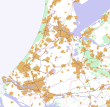
Randstad
Randstad, także Randstad Holland (dosł. „miasto obrzeżne”) – konurbacja w zachodniej Holandii w kształcie podkowy[1], obejmująca aglomeracje: Amsterdamu, Rotterdamu, Utrechtu i Hagi, a także Haarlem, Dordrecht, Leiden i inne miasta. Częściami Randstadu są Zuidvleugel i Groene Hart. Randstad jest ważnym obszarem zurbanizowanym Unii Europejskiej, który w 2009 roku liczył ponad 6,8 mln mieszkańców, co stanowi ponad 40% ludności Holandii[2].
Przypisy
- ↑ Syrkus s.735
- ↑ Randstad Monitor 2011
Bibliografia
- Helena Syrkus: Społeczne cele urbanizacji. Człowiek i środowisko. Warszawa: Państwowe Wydawnictwo Naukowe, 1984, s. 735 - 740. ISBN 83-01-03388-6.
- Wacław Ostrowski: Urbanistyka współczesna. Warszawa: Arkady, 1975, s. 133 - 136.
Linki zewnętrzne
- Regio Randstad
- Die Randstad und das „Grüne Herz“
- „CAHIERS DE L’IAURIF” (135), iau-idf.fr, grudzień 2002 [zarchiwizowane z adresu 2013-07-02].
Media użyte na tej stronie
Autor: Jeroencommons, Licencja: CC-BY-SA-3.0
This is a schematic map of the Randstad, Netherlands.
A few notes:
- Orange: Urban areas (schematic) - the urban areas have been a bit overestimated to show the urban areas more clearly. Areas (like parks) in a city are part of the urban area. Some very small villages are not included. Residential areas, industrial and commercial areas are combined.
- Green: Forests and dunes (schematic)- nearby forests and dunes are combined.
- Light Blue: Sea (schematic)
- Middle Blue: Rivers and lakes (schematic) - smaller rivers, lakes and creeks are not included.
- Red: Highways
- Black: Railways

