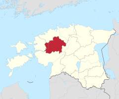
Raplamaa
| Prowincja | |||||
 | |||||
| Państwo | |||||
|---|---|---|---|---|---|
| Siedziba | |||||
| Powierzchnia | 2765 km² | ||||
| Populacja (2018) • liczba ludności |
| ||||
| • gęstość | 12 os./km² | ||||
| Szczegółowy podział administracyjny | |||||
 | |||||
| Liczba gmin | 4 | ||||
| Położenie na mapie (c) Karte: NordNordWest, Lizenz: Creative Commons by-sa-3.0 de | |||||
| Portal | |||||
Prowincja Rapla (est. Rapla maakond) – jedna z 15 prowincji w Estonii, znajdująca się w centralno-zachodniej części kraju.
Podział administracyjny
Prowincja jest podzielona na 4 gmin:
Gminy wiejskie:
Wcześniej, przed reformą administracyjną z 2017 roku, była podzielona na 10 gmin:
Galeria
Media użyte na tej stronie
Autor: Ivar Leidus, Licencja: CC BY-SA 3.0 ee
This is a photo of cultural heritage monument of Estonia number
Autor: Iifar, Licencja: CC BY-SA 3.0 ee
This is a photo of cultural heritage monument of Estonia number
(c) Karte: NordNordWest, Lizenz: Creative Commons by-sa-3.0 de
Location of Rapla County in Estonia
Autor: Ivar Leidus, Licencja: CC BY-SA 3.0 ee
This is a photo of cultural heritage monument of Estonia number
Autor: Kaupo Peetso, Licencja: CC BY-SA 3.0 ee
This is a photo of cultural heritage monument of Estonia number
Autor: Ivar Leidus, Licencja: CC BY-SA 3.0 ee
This is a photo of cultural heritage monument of Estonia number
Autor: Ivar Leidus, Licencja: CC BY-SA 3.0 ee
This is a photo of cultural heritage monument of Estonia number
Autor: Ivar Leidus, Licencja: CC BY-SA 3.0 ee
This is a photo of cultural heritage monument of Estonia number
Autor: Flying Saucer, Licencja: CC BY-SA 4.0
Map of the municipalities of Rapla County after the Administrative Reform of Estonia in 2017.


