Ratak Chain
| ||
 | ||
| Państwo | ||
| Akwen | Ocean Spokojny | |
| Mapa | ||
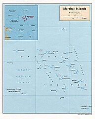
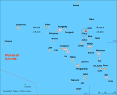
Ratak Chain[1] (pol. „wschód słońca, wschód”[2]) – jeden z dwóch łańcuchów wysp i atoli państwa wyspiarskiego Wysp Marshalla na Oceanie Spokojnym; drugim łańcuchem jest Ralik Chain[1] (pol. „zachód słońca, zachód”[2]).
Położony na wschodzie Wysp Marshalla łańcuch obejmuje dwie wyspy: niezamieszkaną Jemo[1][3] i Mejit[1] oraz 14 atoli[4] o łącznej powierzchni lądu ok. 34 mil kwadratowych (88 km²)[3]:
| L.p. | Zdjęcie | Nazwa atolu[1] | Liczba wysepek | Powierzchnia lądu km² | Powierzchnia laguny km² | Opis |
|---|---|---|---|---|---|---|
| 1 |  | Ailuk | 35[5] | 5,36[5] | 177,34[5] | |
| 2 |  | Arno | 83[6] | 12,95[5] | 338,69[5] | |
| 3 |  | Aur | 42[7] | 5,62[7] | 239,78[7] | |
| 4 |  | Bikar | 6[8] | 0,49[8] | 37,40[8] | Niezamieszkany[3] |
| 5 |  | Bokak | 11[9] | 3,24[9] | 78,08[9] | |
| 6 |  | Erikub | 16[10] | 0,59[10] | 88,92[10] | Niezamieszkany[3] |
| 7 |  | Knox | 18[11] | 0,98[11] | 3,42[11] | Niezamieszkany |
| 8 |  | Likiep | 64[12] | 10,26[12] | 424,01[12] | Historyczne budynki i pozostałości innych budynków i struktur pochodzących z okresu kolonizacji niemieckiej (1880–1937) – Likiep Village Historic District – zostały umieszczone w 2005 roku na liście informacyjnej UNESCO[13]. |
| 9 |  | Majuro | 64[14] | 9,17[14] | 295,05[14] | |
| 10 |  | Maloelap | 71[15] | 9,82[15] | 972,72[15] | |
| 11 |  | Mili | 102[3] 84[16] | 14,98[16] | 759,85[16] | |
| 12 |  | Taka | 5[17] | 0,57[17] | 93,14[17] | Niezamieszkany[3] |
| 13 |  | Utirik | 6[18] | 2,43[18] | 57,73[18] | |
| 14 |  | Wotje | 72[19] | 8,18[19] | 624,34[19] |
Historia
Niewiele wiadomo na temat historii Wysp Marshalla przed przybyciem Europejczyków[20]. Hiszpanie odwiedzali wyspy wielokrotnie w latach 1522–1568[20]. W 1526 roku hiszpański odkrywca Alonso de Salazar jako pierwszy Europejczyk dotarł do Wysp Marshalla, odkrywając atol Bokak[21]. W 1527 roku hiszpański żeglarz Álvaro de Saavedra Cerón (zm. 1529) odkrył atole Toke i Utirik[21]. W 1543 roku hiszpański podróżnik Ruy López de Villalobos (1500–1544) odkrył atole Erikub, Likiep, Maloelap i Wotje[21]. W 1565 roku hiszpański konkwistador Miguel López de Legazpi (1502–1572) odkrył atol Ailuk oraz wyspy Jemoi Mejit[21].
W 1788 roku angielski kapitan John Marshall (1748–1819) odkrył atole Arno, Aur i Majuro[21].
W 1817 roku rosyjski podróżnik i odkrywca Otto von Kotzebue (1788–1846) dotarł do archipelagów Ratak i Ralik na pokładzie statku Rurik[20].
Przypisy
- ↑ a b c d e Nazewnictwo Geograficzne Świata. Zeszyt 1. Komisja Standaryzacji Nazw Geograficznych, 2004, s. 143. ISBN 83-239-7552-3. (pol.)
- ↑ a b Anono Lieom Loeak, Veronica C. Kiluwe, Linda Crowl: Life in the Republic of the Marshall Islands. University of South Pacific Centre Majuro and Institute of Pacific Studies Univeristy of the South Pacific, s. 241. ISBN 978-982-02-0364-8. [dostęp 2016-07-30].
- ↑ a b c d e f Earl R. Hinz, Jim Howard: Landfalls of Paradise: Cruising Guide to the Pacific Islands. University of Hawaii Press, 2006, s. 292. ISBN 978-0-8248-3037-3. [dostęp 2016-07-30].
- ↑ Moshe Rapaport: The Pacific Islands: Environment & Society. Bess Press, 1999, s. 421-426. ISBN 978-1-57306-042-4. [dostęp 2016-07-30].
- ↑ a b c d e Digital Micronesia-An Electronic Library & Archive is: Marshall Islands Atoll Information Ailuk (ang.). [dostęp 2016-07-31].
- ↑ Digital Micronesia-An Electronic Library & Archive is: Marshall Islands Atoll Information Arno (ang.). [dostęp 2016-07-31].
- ↑ a b c Digital Micronesia-An Electronic Library & Archive is: Marshall Islands Atoll Information Aur (ang.). [dostęp 2016-07-31].
- ↑ a b c Digital Micronesia-An Electronic Library & Archive is: Marshall Islands Atoll Information Bikar (ang.). [dostęp 2016-07-31].
- ↑ a b c Digital Micronesia-An Electronic Library & Archive is: Marshall Islands Atoll Information Bokak (Taongi) Atoll (ang.). [dostęp 2016-07-31].
- ↑ a b c Republic of the Marshall Islands - Erikub Atoll (ang.). Republic of the Marshall Islands Embassy, USA, 2002. [dostęp 2016-07-28]. [zarchiwizowane z tego adresu (2013-12-15)].
- ↑ a b c Digital Micronesia-An Electronic Library & Archive is: Marshall Islands Atoll Information Nadikdik (Knox) Atoll (ang.). [dostęp 2016-08-01].
- ↑ a b c Digital Micronesia-An Electronic Library & Archive is: Marshall Islands Atoll Information Likiep Atoll (ang.). [dostęp 2016-07-31].
- ↑ UNESCO: Likiep Village Historic District (ang.). [dostęp 2016-08-01].
- ↑ a b c Digital Micronesia-An Electronic Library & Archive is: Marshall Islands Atoll Information Majuro Atoll (ang.). [dostęp 2016-07-31].
- ↑ a b c Digital Micronesia-An Electronic Library & Archive is: Marshall Islands Atoll Information Maloelap Atoll (ang.). [dostęp 2016-07-31].
- ↑ a b c Digital Micronesia-An Electronic Library & Archive is: Marshall Islands Atoll Information Mile Atoll (ang.). [dostęp 2016-07-31].
- ↑ a b c Digital Micronesia-An Electronic Library & Archive is: Marshall Islands Atoll Information Taka Island (ang.). [dostęp 2016-08-02].
- ↑ a b c Digital Micronesia-An Electronic Library & Archive is: Marshall Islands Atoll Information Utirik Atoll (ang.). [dostęp 2016-07-31].
- ↑ a b c Digital Micronesia-An Electronic Library & Archive is: Marshall Islands Atoll Information Wotje Atoll (ang.). [dostęp 2016-07-31].
- ↑ a b c Anono Lieom Loeak, Veronica C. Kiluwe, Linda Crowl: Life in the Republic of the Marshall Islands. University of South Pacific Centre Majuro and Institute of Pacific Studies Univeristy of the South Pacific, s. 192. ISBN 978-982-02-0364-8. [dostęp 2016-07-30].
- ↑ a b c d e Max Quanchi, John Robson: Historical Dictionary of the Discovery and Exploration of the Pacific Islands. Lanham, Maryland; Toronto; Oxford: The Scarecrow Press, Inc., 2016-08-01, s. XX. ISBN 0-8108-5395-7. (ang.)
Media użyte na tej stronie
Shiny LightSteelBlue button/marker widget. Used to mark the location of something such as a tourist attraction.
Knox Atoll with Klee Passage
Likiep Atoll
Erikub & Wotje Atolls
Atole Mili i Knox (mniejszy, z prawej) w archipelagu Wysp Marshalla
NASA Astronaut Image of Maloelap & Aur Atoll (Ralik Chain, Marshall Islands) in the Pacific Ocean
Composite "true color" multispectral satellite image of Utirik Atoll.
NASA Landsat 8 OLI bands used were 4 (red), 3 (green), 2 (blue). Pan-sharpened with band 8. Manual color balance. Projection: UTM (zone 59), WGS84.
Imagery courtesy NASA/USGS.NASA Astronaut Image of Ailuk Atoll (Ratak Chain, Marshall Islands) in the Pacific Ocean
Autor: Uwe Dedering, Licencja: CC BY-SA 3.0
Relief location map of Pacific_Ocean.
- Projection: Lambert azimuthal equal-area projection.
- Area of interest:
- N: 60.0° N
- S: −80.0° N
- W: −260.0° E
- E: −70.0° E
- Projection center:
- NS: −10.0° N
- WE: −165.0° E
- GMT projection: -JA-165.0/-10.0/180/19.998266666666666c
- GMT region: -R-320.2519138145009/-12.459450078533589/-5.473602099069988/26.40516525873812r
- GMT region for grdcut: -R-325.0/-90.0/-5.0/74.0r
- Relief: SRTM30plus.
- Made with Natural Earth. Free vector and raster map data @ naturalearthdata.com.
Autor: Mr. Minton, Licencja: CC BY 2.0
False color Landsat image of Taka (Toke), RMI, 2000.
visible color satellite image of Majuro Atoll, Marshall Islands, Pacific Ocean
Bikar Atoll, RMI, photographed from the ISS. The original image was trimmed and rotated to orient the top of the image approximately to true North.


