Rathlin
| ||
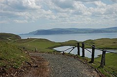
(c) Paul McIlroy, CC BY-SA 2.0 Krajobraz wyspy Rathlin | ||
| Kontynent | Europa | |
| Państwo | ||
| Prowincja | ||
| Akwen | Kanał Północny | |
| Powierzchnia | 14,38 km² | |
Rathlin (ang. Rathlin Island) – wyspa na Kanale Północnym, największa a zarazem jedyna zamieszkana wyspa Irlandii Północnej, położona u północnego wybrzeża Irlandii, administracyjnie część hrabstwa Antrim[1][2].
Wyspa ma powierzchnię 14,38 km²[3]. W 2013 roku liczyła nieco ponad 100 mieszkańców. Tradycyjne zajęcia ludności to rybołówstwo, rolnictwo i szkutnictwo. Współcześnie istotną rolę w lokalnej gospodarce odgrywa turystyka[4].
W 795 roku znajdujący się na wyspie klasztor stał się celem pierwszego w historii najazdu wikińskiego na ziemie irlandzkie. W 1306 roku, po porażce z Anglikami, na wyspie schronienia szukał król Szkocji Robert I Bruce[2].
Wyspa posiada połączenie promowe z położonym na stałym lądzie miastem Ballycastle[2].
Przypisy
- ↑ Route 1: Rathlin Island. W: Helen Fairbairn: Northern Ireland: A Walking Guide. The Collins Press, 2014.
- ↑ a b c The bucolic UK island you've probably never heard of (ang.). The Telegraph, 2018-06-01. [dostęp 2018-08-29].
- ↑ Northern Ireland Statistics and Research Agency (NISRA): Area Measurements in Northern Ireland (ang.). Web Archive. [dostęp 2018-08-29].
- ↑ Haven of peace on Rathlin Island (ang.). BBC, 2013-10-19. [dostęp 2018-08-29].
Media użyte na tej stronie
Autor: Alexrk2, Licencja: CC BY-SA 3.0
Location map of the United Kingdom
Ulster Banner is a heraldic banner taken from the former coat of arms of Northern Ireland. It was used by the Northern Ireland government in 1953-1973 with Edwardian crown since coronation of Queen Elizabeth II, based earlier design with Tudor Crown from 1924. Otherwise known as the Ulster Flag, Red Hand of Ulster Flag, Red Hand Flag.
Ulster Banner is a heraldic banner taken from the former coat of arms of Northern Ireland. It was used by the Northern Ireland government in 1953-1973 with Edwardian crown since coronation of Queen Elizabeth II, based earlier design with Tudor Crown from 1924. Otherwise known as the Ulster Flag, Red Hand of Ulster Flag, Red Hand Flag.
Autor: Nzeemin, Licencja: CC BY-SA 3.0
Relief map of Northern Ireland.
- Projection: Mercator
- Geographic limits of the map:
- W: -8.3° W
- E: -5.3° W
- S: 53.9° N
- N: 55.4° N
(c) Paul McIlroy, CC BY-SA 2.0
Rathlin Island This is Kebble Nature Reserve, Kebble Lough is on the right and in the distance is Fair Head.


