Ratnapura
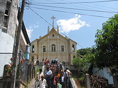
 Katedra Świętych Piotra i Pawła | |
| Państwo | |
|---|---|
| Dystrykt | Ratnapura |
| Populacja • liczba ludności |
|
| Strona internetowa | |
Ratnapura (syng. රත්නපුර, tamil. இரத்தினபுரி) – stolica prowincji Sabaragamuwa w Sri Lance, leży ok. 101 km na wschód od Kolombo. Duży ośrodek wydobycia i handlu kamieniami szlachetnymi: rubinami i szafirami. W pobliżu znajdują się kopalnie wydobywające minerały oraz duże uprawy ryżu, owoców, herbaty i kauczukowca. W 1901 r. populację Ratnapury liczono na 4,084 osób, w 2001 wzrosła do 46,309.
Media użyte na tej stronie
Autor: Uwe Dedering, Licencja: CC BY-SA 3.0
Location map of Sri Lanka.
Equirectangular projection. Strechted by 101.0%. Geographic limits of the map:
- N: 10.2° N
- S: 5.5° N
- W: 79.2° E
- E: 82.3° E
Autor: Terrance Rengarasu, Licencja: CC-BY-SA-3.0
Ss.Peter-Paul Catholic church was built in hill inside the town of Ratnapura. The current Church is said to be inspired by Joseph Vass the Apostle of Ceylon during the 17th century when he visited Ratnapura as a part of his apostolic mission to Sabaragamuwa. After Sabaragamuwa became a diocese on 2 November 1995 Peter-Paul Church was raised to the stats of Cathedral of the diocese.


