Red River (dopływ jeziora Winnipeg)
| Ten artykuł od 2014-04 wymaga zweryfikowania podanych informacji. |
| ||
 Rzeka Red River | ||
| Kontynent | Ameryka Północna | |
| Państwo | ||
| Rzeka | ||
| Długość | 885 km | |
| Powierzchnia zlewni | 297 000 km² | |
| Średni przepływ | 240 m³/s | |
| Źródło | ||
| Współrzędne | 46°15′51,5″N 96°35′55,7″W/46,264300 -96,598800 | |
| Ujście | ||
| Recypient | jeziora Winnipeg | |
| Współrzędne | 50°23′47,0″N 96°48′39,0″W/50,396390 -96,810830 | |
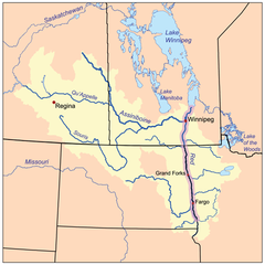
Red River (fr. Rivière Rouge) – rzeka w USA i Kanadzie. Długość 885 km, średni przepływ 240 m³/s, powierzchnia dorzecza 297 000 km². W Stanach Zjednoczonych często używa się nazwy Red River of the North dla odróżnienia od tak samo nazywającej się rzeki na granicy stanów Teksas i Oklahoma.
Rzeka ta powstaje z połączenia rzek Bois de Sioux oraz Otter Tail, a uchodzi do jeziora Winnipeg.
Od miasta Fargo Red River jest żeglowna.
Główne miasto nad rzeką Red River to Winnipeg.
Media użyte na tej stronie
Autor: Yug, Licencja: CC-BY-SA-3.0
cropped version of Carte administrative du Canada.svg for map location.
The flag of Navassa Island is simply the United States flag. It does not have a "local" flag or "unofficial" flag; it is an uninhabited island. The version with a profile view was based on Flags of the World and as a fictional design has no status warranting a place on any Wiki. It was made up by a random person with no connection to the island, it has never flown on the island, and it has never received any sort of recognition or validation by any authority. The person quoted on that page has no authority to bestow a flag, "unofficial" or otherwise, on the island.
Autor: Tim Kiser (w:User:Maleaphasant), Licencja: CC BY-SA 2.5
The w:Red River of the North in w:Fargo-Moorhead, as viewed from the Fargo side of the river.


