Redding (Kalifornia)
| |||||
| |||||
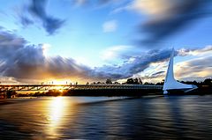
 Most Sundial nad rzeką Sacramento w Redding | |||||
| |||||
| Przydomek: Jewel of Northern California | |||||
| Państwo | |||||
| Stan | |||||
| Hrabstwo | Shasta | ||||
| Data założenia | 1873 | ||||
| Prawa miejskie | 1887 | ||||
| Kod statystyczny | FIPS: 06-59920 GNIS ID: 0277582 | ||||
| Zarządzający | Missy McArthur | ||||
| Powierzchnia | 158,442[1] km² | ||||
| Populacja (2009) • liczba ludności • gęstość | 90 521 586,0 os./km² | ||||
| Nr kierunkowy | 530 | ||||
| Kod pocztowy | 96001, 96002, 96003, 96049, 96099 | ||||
| Strefa czasowa | UTC-08:00 UTC-07:00 | ||||
| Strona internetowa | |||||
| Portal | |||||
Redding – miasto (city), ośrodek administracyjny hrabstwa Shasta, w stanie Kalifornia, w Stanach Zjednoczonych. W 2009 roku miasto liczyło 90 521 mieszkańców[2].
Redding położone jest w północnej części doliny Sacramento, nad rzeką o tej samej nazwie.
Sport
W mieście rozgrywany jest kobiecy turniej tenisowy, pod nazwą The Ascension Project Women's Challenger, zaliczany do rangi ITF, z pulą nagród $25 000[3].
Z Redding pochodzi Megan Rapinoe, reprezentantka USA w piłce nożnej.
Przypisy
- ↑ Gazetteer (ang.). U.S. Census Bureau. [dostęp 2012-01-06].
- ↑ Redding, California (ang.). City-Data.com. [dostęp 2011-02-17].
- ↑ The Ascension Project Women’s $25,000 Challenger.
Media użyte na tej stronie
Autor: NordNordWest, Licencja: CC BY 3.0
Location map of California, USA
Autor: Uwe Dedering, Licencja: CC BY-SA 3.0
Location map of the USA (without Hawaii and Alaska).
EquiDistantConicProjection:
Central parallel:
* N: 37.0° N
Central meridian:
* E: 96.0° W
Standard parallels:
* 1: 32.0° N
* 2: 42.0° N
Made with Natural Earth. Free vector and raster map data @ naturalearthdata.com.
Formulas for x and y:
x = 50.0 + 124.03149777329222 * ((1.9694462586094064-({{{2}}}* pi / 180))
      * sin(0.6010514667026994 * ({{{3}}} + 96) * pi / 180))
y = 50.0 + 1.6155950752393982 * 124.03149777329222 * 0.02613325650382181
      - 1.6155950752393982  * 124.03149777329222 *
     (1.3236744353715044  - (1.9694462586094064-({{{2}}}* pi / 180))
      * cos(0.6010514667026994 * ({{{3}}} + 96) * pi / 180))
The flag of Navassa Island is simply the United States flag. It does not have a "local" flag or "unofficial" flag; it is an uninhabited island. The version with a profile view was based on Flags of the World and as a fictional design has no status warranting a place on any Wiki. It was made up by a random person with no connection to the island, it has never flown on the island, and it has never received any sort of recognition or validation by any authority. The person quoted on that page has no authority to bestow a flag, "unofficial" or otherwise, on the island.
Flag of California. This version is designed to accurately depict the standard print of the bear as well as adhere to the official flag code regarding the size, position and proportion of the bear, the colors of the flag, and the position and size of the star.
Seal of Redding, California
Autor: inderwadhwa, Licencja: CC BY-SA 3.0
Picture of Sun Dial bridge located in Redding, CA
Picture by Inder WadhwaFlag of Redding, California


