Redlands (Kalifornia)
| ||||
 | ||||
| Przydomek: Jewel of the Inland Empire | ||||
| Państwo | ||||
|---|---|---|---|---|
| Stan | ||||
| Hrabstwo | ||||
| Prawa miejskie | 1888 | |||
| Kod statystyczny | ||||
| Zarządzający | Pete Aguilar | |||
| Powierzchnia | 94,344 km² | |||
| Wysokość | 414 m n.p.m. | |||
| Populacja (2010) • liczba ludności • gęstość |
| |||
| Nr kierunkowy | 909 | |||
| Kod pocztowy | 92373, 92374 | |||
| Strefa czasowa | ||||
| Strona internetowa | ||||
| Portal | ||||
Redlands – miasto w Stanach Zjednoczonych położone w południowo-zachodniej części hrabstwa San Bernardino w Kalifornii. Liczba mieszkańców 63.591 (2008).
Położenie
Redlands położone jest w rejonie metropolitalnym Los Angeles, oraz w regionie Inland Empire. Znajduje się ok. 103 km na wschód od Los Angeles i ok. 16 km na południowy wschód, od stolicy hrabstwa, miasta San Bernardino. Miasto rozdziela na pół autostrada międzystanowa nr 15.
Historia
W XVIII wieku, po przybyciu pierwszych osadników tereny dzisiejszego Redlands znalazły się w granicach Rancza San Bernardino. Osadnictwo rozpoczęło się w 1865 roku, jego intensyfikacja nastąpiła po wybudowaniu linii kolejowej łączącej południowa Kalifornię z San Francisco. W 1888 roku miejscowość otrzymała prawa miejskie. Nazwa miasta pochodzi od koloru gleby adobe na jakiej jest wybudowane.
W Redlands znajduje się kilka szkół wyższych, w tym University of Redlands.
Miasta partnerskie
Linki zewnętrzne
- Oficjalna strona miasta
- Strona Izby Handlowej Redlands. redlandschamber.org. [zarchiwizowane z tego adresu (2009-02-28)].
Media użyte na tej stronie
Autor: NordNordWest, Licencja: CC BY 3.0
Location map of California, USA
Autor: Uwe Dedering, Licencja: CC BY-SA 3.0
Location map of the USA (without Hawaii and Alaska).
EquiDistantConicProjection:
Central parallel:
* N: 37.0° N
Central meridian:
* E: 96.0° W
Standard parallels:
* 1: 32.0° N
* 2: 42.0° N
Made with Natural Earth. Free vector and raster map data @ naturalearthdata.com.
Formulas for x and y:
x = 50.0 + 124.03149777329222 * ((1.9694462586094064-({{{2}}}* pi / 180))
      * sin(0.6010514667026994 * ({{{3}}} + 96) * pi / 180))
y = 50.0 + 1.6155950752393982 * 124.03149777329222 * 0.02613325650382181
      - 1.6155950752393982  * 124.03149777329222 *
     (1.3236744353715044  - (1.9694462586094064-({{{2}}}* pi / 180))
      * cos(0.6010514667026994 * ({{{3}}} + 96) * pi / 180))
The flag of Navassa Island is simply the United States flag. It does not have a "local" flag or "unofficial" flag; it is an uninhabited island. The version with a profile view was based on Flags of the World and as a fictional design has no status warranting a place on any Wiki. It was made up by a random person with no connection to the island, it has never flown on the island, and it has never received any sort of recognition or validation by any authority. The person quoted on that page has no authority to bestow a flag, "unofficial" or otherwise, on the island.
Flag of California. This version is designed to accurately depict the standard print of the bear as well as adhere to the official flag code regarding the size, position and proportion of the bear, the colors of the flag, and the position and size of the star.
Autor: Arkyan, Licencja: CC-BY-SA-3.0
This map shows the incorporated and unincorporated areas in San Bernardino County, California, highlighting Redlands in red. It was created with a custom script with US Census Bureau data and modified with Inkscape.
Autor: Ron Reiring, Licencja: CC BY 2.0
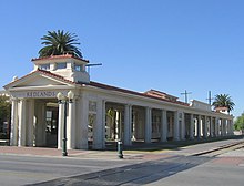
Abandoned AT&SF station in downtown Redlands, built in 1910, but still in pretty good condition.
Autor: Don Graham from Redlands, CA, USA - God bless it!, Licencja: CC BY-SA 2.0
(1 in a multiple picture album)
I take a lot of pictures of this chapel because . . . I like it.


