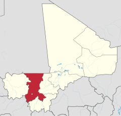
Region Koulikoro
| Region | |
 | |
| Państwo | |
|---|---|
| Siedziba | |
| Kod ISO 3166-2 | ML-2 |
| Powierzchnia | 95 848 km² |
| Populacja (2009[1]) • liczba ludności |
|
| • gęstość | 26,9 os./km² |
Położenie na mapie | |
Region Koulikoro – jeden z 8 regionów w Mali, znajdujący się w południowo-zachodniej części kraju.
Przypisy
- ↑ Institut National de la Statistique (INSTAT): REGION DE KOULIKORO. [dostęp 2013-11-30]. (fr.).
Media użyte na tej stronie
Mali - Koulikoro.svg
Autor:
Location of Region X in Mali
Autor:
- Derivative work: User:Profoss *Original work: NordNordWest
Location of Region X in Mali
Un-koulikoro region.png
Autor: editing, crop, addition of places, by T L Miles (talk) 20:23, 8 October 2008 (UTC), Licencja: CC-BY-SA-3.0
A map of the Koulikoro Region of Mali, derived from United Nations Cartography Section map Image:Un-mali.png
Autor: editing, crop, addition of places, by T L Miles (talk) 20:23, 8 October 2008 (UTC), Licencja: CC-BY-SA-3.0
A map of the Koulikoro Region of Mali, derived from United Nations Cartography Section map Image:Un-mali.png
Koulikoro cercles.png
Map of the cercles of Koulikoro region in Mali. using MapInfo Professional v8.5 and various mapping resources.
Map of the cercles of Koulikoro region in Mali. using MapInfo Professional v8.5 and various mapping resources.


