Region Ludu Hareri
| Region | |||||
 Miasto Harar | |||||
| |||||
| Państwo | |||||
|---|---|---|---|---|---|
| Siedziba | |||||
| Kod ISO 3166-2 | ET-HA | ||||
| Powierzchnia | 340 km² | ||||
| Populacja (2005) • liczba ludności |
| ||||
| • gęstość | 576,5 os./km² | ||||
Położenie na mapie | |||||
Region Ludu Hareri (amh. ሀረሪ ሕዝብ ክልል) – jeden z regionów administracyjnych we wschodniej części Etiopii, otoczony ze wszystkich stron przez region Oromia. Stolicą regionu jest miasto Harar.
Region liczy 196 000 mieszkańców (2005 r.) i zajmuje powierzchnię 340 km².
- Skład etniczny: Oromowie 56,4%, Amharowie 22,8%, Harari 8,7%, Gurage 4,3%, Somalowie 3,9%,
- Język urzędowy: harari,
- Religie: muzułmanie 69,0%, koptyjscy chrześcijanie 27,1%, protestanci 3,4%, katolicy 0,3%.
Linki zewnętrzne
Media użyte na tej stronie
Flag of Ethiopia
Autor: A. Davey from Where I Live Now: Pacific Northwest, Licencja: CC BY 2.0
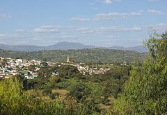
This is the ancient walled city of Harar in southeastern Ethiopia. The fourth-holiest site in Islam, Harar was off-limits to most outsiders until the late 19th century.
While the ancient city walls are not visible in this photo, their presence is evident in the sharp demarcation between the urbanized area and the surrounding countryside. Here, there is no urban sprawl.Emblem of the Harari Region
Autor: TUBS
Location of region XY (see filename) in Ethiopia


