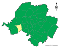
Reichenbrand
| Dzielnica Chemnitz | |
 | |
| Państwo | |
|---|---|
| Kraj związkowy | Saksonia |
| Miasto | Chemnitz |
| W granicach Chemnitz | 1 lipca 1950 |
| Powierzchnia | 4,37 km² |
| Populacja (31 grudnia 2012) • liczba ludności | 6 390 |
| • gęstość | 1 462 os./km² |
| Strefa numeracyjna | 0371 |
| Kod pocztowy | 09117 |
| Tablice rejestracyjne | C |
Położenie na mapie Chemnitz | |
| 50°48′N 12°49′E/50,800000 12,816667 | |
| Strona internetowa | |
| Portal | |
Altchemnitz, Chemnitz-Reichenbrand – dzielnica miasta Chemnitz w Niemczech, w kraju związkowym Saksonia.
Bibliografia
- Statistisches Landesamt des Freistaates Sachsen, Kamenz
Media użyte na tej stronie
Stadtteil-Chemnitz-Reichenbrand.svg
Lage des Stadtteils Reichenbrand in Chemnitz
Lage des Stadtteils Reichenbrand in Chemnitz
Coat of arms of Chemnitz.svg
Coat of arms of Chemnitz
Coat of arms of Chemnitz
Reichenbrander Johanniskirche.jpg
Autor: KlemmEric, Licencja: CC BY-SA 3.0
Blick zur Johanniskirche und zum ehemaligen Rathaus mit seinem glockenförmigen Turm. Links vom Kirchturm ist die Kuppel der Schule sichtbar. Blick in die Hohensteiner Straße.
Autor: KlemmEric, Licencja: CC BY-SA 3.0
Blick zur Johanniskirche und zum ehemaligen Rathaus mit seinem glockenförmigen Turm. Links vom Kirchturm ist die Kuppel der Schule sichtbar. Blick in die Hohensteiner Straße.


