Resolution Island (Nunavut)
 Zdjęcie satelitarne wysp Resolution i Edgell | |
| Kontynent | |
|---|---|
| Państwo | |
| Terytorium | |
| Akwen | |
| Archipelag | |
| Powierzchnia | 1015 km² |
| Populacja • liczba ludności |
|
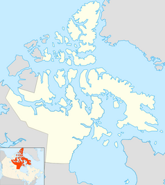
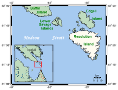
Resolution Island (inuktitut: Tutjah[1]) − wyspa na Morzu Labradorskim, położona przy południowo-wschodnim brzegu Ziemi Baffina, u wejścia do cieśnina Davisa na terytorium Nunavut, w Kanadzie. Zajmuje powierzchnię 1015 km2[2]. W języku lokalnych Inuitów wyspa nosi nazwę Tutjah, która oznacza "miejsce, w którym lądują ptaki"[1].
Odkrył ją angielski podróżnik Martin Frobisher, który jako pierwszy wylądował na wyspie 28 lipca 1576.
Przypisy
- ↑ a b Douglas Kroeker: Remediation on Resolution Island (ang.). www.hazmatmag.com, kwiecień 2001. [dostęp 2010-10-17].
- ↑ Sea Islands (ang.). www.atlas.nrcan.gc.ca. [dostęp 2010-10-17].
Media użyte na tej stronie
Autor: Nzeemin, Licencja: CC BY-SA 3.0
Relief map of Canada.
- Projection: Lambert Conformal Conic Projection
- lon0 = -27°
- lat0 = 69°
- lat1 = 51°
- lat2 = 45°
- Projection/coords for GMT:
-Jl-95/49/49/77/1:29350000 -R-121.36/38.29/-11.5/63.0r
Terra MODIS satellite image of Resolution and Edgell Island, Nunavut, Canada
(c) Kelisi z angielskojęzycznej Wikipedii, CC-BY-SA-3.0
A map, with inset, of Resolution Island, Nunavut, Canada. This map's source is here, with the uploader's modifications, and the GMT homepage says that the tools are released under the GNU General Public License.
Autor: Algkalv and Dr. Blofeld based on original by Yug. Inset map is by EOZyo. Two maps put together by Ruhrfisch (talk), Licencja: CC BY-SA 3.0
Map of Nunavut
Flag of Nunavut


