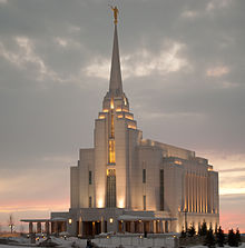
Rexburg
 Główna ulica w Rexburg. | |
| Państwo | |
|---|---|
| Stan | |
| Hrabstwo | |
| Powierzchnia | 26,15 km² |
| Wysokość | 1483 m n.p.m. |
| Populacja (2019) • liczba ludności • gęstość |
|
| Nr kierunkowy | 208 |
| Kod pocztowy | 83440, 83441, 83460 |
| Podział miasta | 12 dzielnic |
| Strona internetowa | |
| Portal | |
Rexburg – miasto w Stanach Zjednoczonych, w stanie Idaho, stolica hrabstwa Madison. W 2019 roku liczyło 29,4 tys. mieszkańców i jest dwunastym co do wielkości miastem w stanie[1].
Historia
Założone przez rolników mormońskich pod wodzą Thomasa Ricksa w 1883 roku. Leży w nawadnianym regionie rolniczym równiny Snake River i jest ośrodkiem produkcji zbożowej i mleczarskiej[2].
Dwie trzecie miasta zostało zniszczone w dniu 5 czerwca 1976 r., kiedy to zawaliła się Tama Grand Teton, wylewając ogromne ilości wody na równinę i zmuszając do ewakuacji ponad 300 tys. mieszkańców Idaho. W powodzi zginęło 11 osób. Miasto odrodziło się i odbudowało, a od lat 90. XX wieku znacznie wzrosło zaludnienie[2].
Religia
Jest to najbardziej mormońskie miasto w Stanach Zjednoczonych, gdzie 91,4% populacji określa się jako mormoni[3]. W mieście znajduje się Brigham Young University–Idaho, prywatna instytucja prowadzona przez Kościół Jezusa Chrystusa Świętych w Dniach Ostatnich[2].
Miasta partnerskie
Przypisy
- ↑ US Census Bureau, City and Town Population Totals: 2010-2019, The United States Census Bureau [dostęp 2021-05-31] (ang.).
- ↑ a b c Rexburg, [w:] Encyclopædia Britannica [online] [dostęp 2021-05-31] (ang.).
- ↑ Latter-day Saints Metro Areas (2010) -QuickLists, www.thearda.com [dostęp 2021-05-31].
Media użyte na tej stronie
Autor: Uwe Dedering, Licencja: CC BY-SA 3.0
Location map of the USA (without Hawaii and Alaska).
EquiDistantConicProjection:
Central parallel:
* N: 37.0° N
Central meridian:
* E: 96.0° W
Standard parallels:
* 1: 32.0° N
* 2: 42.0° N
Made with Natural Earth. Free vector and raster map data @ naturalearthdata.com.
Formulas for x and y:
x = 50.0 + 124.03149777329222 * ((1.9694462586094064-({{{2}}}* pi / 180))
      * sin(0.6010514667026994 * ({{{3}}} + 96) * pi / 180))
y = 50.0 + 1.6155950752393982 * 124.03149777329222 * 0.02613325650382181
      - 1.6155950752393982  * 124.03149777329222 *
     (1.3236744353715044  - (1.9694462586094064-({{{2}}}* pi / 180))
      * cos(0.6010514667026994 * ({{{3}}} + 96) * pi / 180))
The flag of Navassa Island is simply the United States flag. It does not have a "local" flag or "unofficial" flag; it is an uninhabited island. The version with a profile view was based on Flags of the World and as a fictional design has no status warranting a place on any Wiki. It was made up by a random person with no connection to the island, it has never flown on the island, and it has never received any sort of recognition or validation by any authority. The person quoted on that page has no authority to bestow a flag, "unofficial" or otherwise, on the island.
Autor: Pavili255, Licencja: CC BY-SA 4.0
A high resolution picture of the Rexburg, Idaho temple at sunset.
Autor: Ken Lund from Reno, Nevada, USA, Licencja: CC BY-SA 2.0
Rexburg is a city in Madison County, Idaho, United States. The population was 25,484 at the 2010 census, up from 17,257 in 2000. The city is the county seat of Madison County and its largest city. Rexburg is the principal city of the Rexburg, ID Micropolitan Statistical Area, which includes Fremont and Madison Counties. The city is home to Brigham Young University-Idaho, a private institution operated by The Church of Jesus Christ of Latter-day Saints.
The city takes its name from Ricks, the German form of which is "Rex", after founder Thomas Edwin Ricks. The city was incorporated in 1883.
Rexburg was severely damaged by the famous Teton Dam Flood of June 1976. The Teton River flowed through northern Rexburg, and left most of the city underwater for several days after the Teton Dam ruptured. Cooperation of the people within the community quickened the recovery. A museum dedicated to the Teton Dam Flood and the history of Rexburg and the area, located in the basement of the Rexburg Tabernacle, has been a major city landmark for decades. Upon its dedication in February 2008, the Rexburg Idaho Temple made Rexburg the third city in Idaho with an LDS temple.
Since the announcement of the transition from Ricks College to Brigham Young University-Idaho the population of Rexburg has grown dramatically.
<a href="http://en.wikipedia.org/wiki/Rexburg,_Idaho" rel="nofollow">en.wikipedia.org/wiki/Rexburg,_Idaho</a>
en.wikipedia.org/wiki/Wikipedia:Text_of_Creative_Commons_...


