Rezerwaty biosfery w Afryce

Rezerwaty biosfery w Afrycerezerwaty biosfery na terenie Afryki.

W 2018 roku w Afryce było 101 rezerwatów biosfery w 35 krajach[a].

Lista rezerwatów

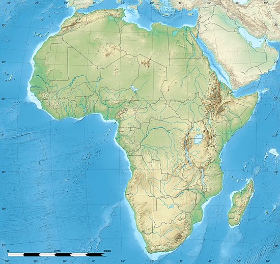
Mapa konturowa Afryki
(c) Eric Gaba, Wikimedia Commons user Sting, CC BY-SA 3.0
Geographylogo.svg
Rezerwaty biosfery w Afryce, numeracja odpowiada poniższemu zestawieniu (stan na 2018 rok)

Poniższa tabela przedstawia rezerwaty biosfery w Afryce.Lista pogrupowana jest według państw i lat ustanowienia rezerwatu. Informacje szczegółowe podane są za stronami rezerwatów w portalu rezerwatów biosfery UNESCO[1].

Nazwa rezerwatu biosfery;
Rok utworzenia – rok utworzenia/poszerzenia rezerwatu;
Powierzchnia – powierzchnia rezerwatu w km²;
Położenie – państwo, region; współrzędne geograficzne;
Uwagi – informacje na temat rezerwatu, posiadanych certyfikatów, przyznanych nagród i wyróżnień międzynarodowych itp.
Zestawienie rezerwatów biosfery w Afryce
Lp.ZdjęcieNazwa rezerwatu biosferyRok utworzeniaPowierzchnia
(km²)
PołożenieUwagi
Algieria
1.Tassili rocks.jpgRezerwat biosfery Tasili Wan Ahdżar198672000Algieria
Prowincja Illizi
25°30′00″N 9°00′00″E/25,500000 9,000000
Światowe dziedzictwo UNESCO (1982)[3]
2.GM Parc national El Kala01.jpgRezerwat biosfery Al-Kala1990763,48Algieria
Prowincja At-Tarif
36°49′00″N 8°25′00″E/36,816667 8,416667
3.Djurdjura.Neige.jpgRezerwat biosfery Dżurdżura1997356,6Algieria
Prowincja Tizi Wuzu
36°28′00″N 4°11′00″E/36,466667 4,183333
4.Montagne de Chréa,.jpgRezerwat biosfery Asz-Szaria2002369,85Algieria
Prowincja Al-Bulajda
36°21′00″N 2°45′00″E/36,350000 2,750000
5.Tazza algeria2.jpgRezerwat biosfery Taza200416,43Algieria
Prowincja Dżidżal
36°36′00″N 5°30′00″E/36,600000 5,500000
6.Les Aiguades.jpgRezerwat biosfery Kuraja200420,8Algieria
Prowincja Bidżaja
36°46′00″N 5°06′00″E/36,766667 5,100000
7.Belezma.JPGRezerwat biosfery Billizma201572,65Algieria
Prowincja Batina
35°34′00″N 6°01′00″E/35,566667 6,016667
8.Tlemcen, Algeria - Ruin of Mansoura.jpgRezerwat biosfery Tilimsan2016985,32Algieria
Prowincja Tilimsan
34°52′00″N 1°18′00″W/34,866667 -1,300000
Benin
9.Rezerwat biosfery Pendjari19865750Benin
Departament Atakora
11°15′00″N 1°31′05″E/11,250000 1,518056
Światowe dziedzictwo UNESCO (2017)[4]
10.Elephants bath park w wide 2006.jpgRezerwat biosfery region „W”200220483,13 (pow. całk. 35046,48)Benin
Departament Alibori
12°31′31″N 2°39′48″E/12,525278 2,663333
Rezerwat transgraniczny z Burkiną Faso i Nigrem; Światowe dziedzictwo UNESCO (1996)[4]
11.Cours du Mono au Bénin (31).jpgRezerwat Biosfery Mono2017Benin
Departament Atlantique
6°34′29,6″N 1°37′29,8″E/6,574889 1,624944
Rezerwat transgraniczny z Togo
Burkina Faso
12.Mare aux hippos MS 2068.jpgRezerwat biosfery Mare aux Hippopotames1986192Burkina Faso
Prowincja Houet
11°36′43″N 3°55′00″W/11,611944 -3,916667
W 1990 roku wpisany na listę konwencji ramsarskiej[5]
13.Elephants bath park w wide 2006.jpgRezerwat biosfery region „W”20027283,35 (pow. całk. 35046,48)Burkina Faso
Prowincja Tapoa
12°31′31″N 2°39′48″E/12,525278 2,663333
Rezerwat transgraniczny z Beninem i Nigrem; Światowe dziedzictwo UNESCO (1996)[4]; W 1990 roku wpisany na listę konwencji ramsarskiej[6]
14.Arli-NP MS1219.jpgRezerwat biosfery Arly201821206,8Burkina Faso
Prowincja Tapoa11°35′00″N 1°28′00″E/11,583333 1,466667
Światowe dziedzictwo UNESCO (2017)[4]
Demokratyczna Republika Konga
15.Rezerwat biosfery Yangambi19762350Demokratyczna Republika Konga
Kongo Środkowe
0°38′00″N 24°16′00″E/0,633333 24,266667
16.Rezerwat biosfery Luki1976330Demokratyczna Republika Konga
Kongo Środkowe
5°56′03″S 12°20′58″E/-5,934167 12,349444
17.Rezerwat biosfery Lufira1982147Demokratyczna Republika Konga
Katanga
10°58′53″S 26°44′00″E/-10,981389 26,733333
Egipt
18.Testudo kleinmanni at Omayed Protected Area in 2017 , photo by Hatem Moushir 19.jpgRezerwat biosfery Al-Umajjid1981
1998
758Egipt
Matruh
30°45′00″N 29°09′00″E/30,750000 29,150000
19.Rezerwat biosfery Wadi al-Allaki199323800Egipt
Asuan
22°10′00″N 33°10′00″E/22,166667 33,166667
Etiopia
20.Rezerwat biosfery Kafa20105406,3Etiopia
Region Narodów, Narodowości i Ludów Południa
7°22′14″N 36°03′22″E/7,370556 36,056111
21.Rezerwat biosfery Yayu20101670,21Etiopia
Oromia
8°20′14″N 35°49′02″E/8,337222 35,817222
22.Rezerwat biosfery las Sheka20122387,5Etiopia
Region Narodów, Narodowości i Ludów Południa
7°33′50,1″N 35°24′12,7″E/7,563919 35,403531
23.Lake Tana, Ethiopia.jpgRezerwat biosfery jeziora Tana20156958,85Etiopia
Amhara
11°54′29″N 37°20′40″E/11,908056 37,344444
24.Rezerwat biosfery las Majang20172254,9Etiopia
7°25′35″N 35°07′50″E/7,426389 35,130556
Gabon
25.Rezerwat biosfery Ipassa-Makokou1983150Gabon
Ogowe-Ivindo
0°31′00″N 12°48′00″E/0,516667 12,800000
Ghana
26.Umbrella canopy tree.jpgRezerwat biosfery Bia198377Ghana
Region Zachodni
6°35′00″N 3°05′00″W/6,583333 -3,083333
27.Rezerwat biosfery Songor2011511Ghana
Region Wielka Akra
5°45′00″N 0°30′00″E/5,750000 0,500000
W 1992 roku wpisany na listę konwencji ramsarskiej[7]
28.Bosumtwi Worldwind SW.jpgRezerwat biosfery Bosumtwi2016287Ghana
Region Aszanti
6°30′26″N 1°24′24″W/6,507222 -1,406667
Gwinea
29.Mount Nimba Strict Nature Reserve-108445.jpgRezerwat biosfery Nimba19801452Gwinea
Nzérékoré
7°37′21″N 8°24′20″W/7,622500 -8,405556
Światowe dziedzictwo UNESCO (1981)[8]
30.Lowland rainforest of Ziama Massif.jpgRezerwat biosfery Ziama19801,2Gwinea
Nzérékoré
7°33′40″N 8°27′52″W/7,561111 -8,464444
31.Rezerwat biosfery Badiar20022843Gwinea
Boké
12°37′00″N 13°19′00″W/12,616667 -13,316667
32.Savanna woodland in the National Park of Upper Niger.jpgRezerwat biosfery Górnego Nigru20026470Gwinea
Faranah
10°30′00″N 10°12′00″W/10,500000 -10,200000
Gwinea Bissau
33.Bissagos archipel-satellite.jpgRezerwat biosfery Boloma Bijagós19961012Gwinea Bissau
Region Bolama
11°20′30″N 15°59′00″W/11,341667 -15,983333
Kamerun
34.Elephants around tree in Waza, Cameroon.jpgRezerwat biosfery Waza19793000Kamerun
Region Dalekiej Północy
11°16′31″N 14°42′59″W/11,275278 -14,716389
35.BénouéNP4.jpgRezerwat biosfery Bénoué19817004Kamerun
Region Północny
8°17′30″N 13°47′29″W/8,291667 -13,791389
36.Crossing the Dja on a ferry.jpgRezerwat biosfery Dja1981800Kamerun
Region Wschodni
3°01′31″N 12°59′59″E/3,025278 12,999722
Światowe dziedzictwo UNESCO (1987)[9]
Kenia
37.Rezerwat biosfery Mount Kenya1978717,6Kenia
0°09′22″N 37°19′05″E/0,156111 37,318056
Światowe dziedzictwo UNESCO (1997)[10]
38.Rezerwat biosfery Mount Kulal19787000Kenia
Marsabit
2°43′45″N 36°55′24″E/2,729167 36,923333
39.Rezerwat biosfery Malindi-Watamu1979196Kenia
Kilifi
3°22′04″S 40°00′59″E/-3,367778 40,016389
40.Rezerwat biosfery Kiunga1980600Kenia
1°55′19″S 41°21′14″E/-1,921944 41,353889
41.Elephants Kili 2.jpgRezerwat biosfery Amboseli19914832Kenia
2°37′36,1″S 37°15′15,5″E/-2,626700 37,254300
42.Mount Elgon Forest.jpgRezerwat biosfery Mount Elgon20032088Kenia
Kajiado
1°08′00″N 34°33′00″E/1,133333 34,550000
Kongo
43.Rezerwat biosfery Odzala19771100Kongo
Cuvette-Ouest0°40′00″N 14°52′00″E/0,666667 14,866667
44.Rezerwat biosfery Dimonika19881360Kongo
Kouilou4°10′00,1″S 12°25′00,1″E/-4,166701 12,416700
Madagaskar
45.Rezerwat biosfery Mananara Nord19901400Madagaskar
Prowincja Toamasina
16°10′01″S 49°45′20″E/-16,166944 49,755556
46.Rezerwat biosfery Sahamalaza-Iles Radama20011532Madagaskar
Prowincja Antsiranana
Prowincja Mahajanga
14°10′00″S 47°42′00″E/-14,166667 47,700000
47.Rezerwat biosfery Littoral de Toliara20032005Madagaskar
23°23′00″S 45°05′00″E/-23,383333 45,083333
48.Rezerwat biosfery Belo-sur-Mer–Kirindy-Mite20166250Madagaskar
20°50′27″S 44°01′45″E/-20,840833 44,029167
49.Rezerwat biosfery Tsimanampesotse–Nosy Ve Androka201817770Madagaskar
24°24′34″S 44°09′18″E/-24,409444 44,155000
Malawi
50.Mulanje ETM 26may02.jpgRezerwat Biosfery Mlandżi200064Malawi
Dystrykt Mlandżi
15°54′00″S 35°39′00″E/-15,900000 35,650000
51.Lake Chilwa NASA.jpgRezerwat Biosfery Chilwa20066142Malawi
Dystrykt Zombo
15°18′00″S 35°42′00″E/-15,300000 35,700000
Mali
52.Rezerwat Biosfery Boucle du Baoulé198225000Mali
Region Kayes
Region Koulikoro
14°00′00″N 9°00′00″W/14,000000 -9,000000
Maroko
53.Argania spinosa habitat2.jpgRezerwat Biosfery Arganeraie199825688Maroko
30°17′00″N 8°18′00″W/30,283333 -8,300000
54.DraaValley.jpgRezerwat Biosfery oazy marokańskiego południa200071854Maroko
30°48′00″N 5°40′00″W/30,800000 -5,666667
55.Międzykontynentalny Rezerwat Biosfery Morza Śródziemnego20068941Maroko
36°01′52″N 5°36′05″W/36,031111 -5,601389
Rezerwat transgraniczny z Hiszpanią
56.مضايق تودغى التي يزورها السياح من مختلف أنحاء العالم.jpgRezerwat Biosfery Cedru Atlaskiego201613750Maroko
33°01′10″N 5°18′31″W/33,019444 -5,308611
Mauretania
57.ISS002-E-5456 2.JPGRezerwat Biosfery Delta Senegalu20056418Mauretania
16°30′00″N 16°20′00″W/16,500000 -16,333333
Rezerwat transgraniczny z Senegalem.
Mauritius
58.Black River Gorges National Park, Mauritius.jpgRezerwat Biosfery Macchabee/Bel Ombre197736Mauritius
20°25′00″S 57°26′00″E/-20,416667 57,433333
Mozambik
59.Medjumbe Island Pool Deck.jpgRezerwat Biosfery Quirimba201814812Mozambik
Cabo Delgado
12°36′04″S 39°58′56″E/-12,601111 39,982222
Niger
60.Timia valley.JPGRezerwat Biosfery Aïr et Ténéré1997239700Niger
18°51′20″S 9°30′40″E/-18,855556 9,511111
61.Elephants bath park w wide 2006.jpgRezerwat biosfery region „W”19967280 (pow. całk. 35046,48)Niger
12°31′31″N 2°39′48″E/12,525278 2,663333
Rezerwat transgraniczny z Beninem i Burkiną Faso; Światowe dziedzictwo UNESCO (1996)[4]
62.Rezerwat biosfery Gadabedji201714136Niger
15°07′51″N 7°10′44″E/15,130833 7,178889
Nigeria
63.OmoRiver1.jpgRezerwat Biosfery Omo19776751Nigeria
6°51′30″S 4°29′30″E/-6,858333 4,491667
Republika Środkowoafrykańska
64.Rezerwat Biosfery Basse-Lobaye1977182Republika Środkowoafrykańska
3°40′00″S 17°50′00″E/-3,666667 17,833333
65.Rezerwat Biosfery Bamingui-Bangoran197916220Republika Środkowoafrykańska
8°09′50,1″N 19°45′07,3″E/8,163919 19,752039
Rwanda
66.Sabyinyo.jpgRezerwat Biosfery Wulkany1983125Rwanda
1°29′35,8″S 29°27′54,0″E/-1,493281 29,464989
Republika Południowej Afryki
67.Rezerwat Biosfery Kogelberg19981036Republika Południowej Afryki
34°14′01″S 18°59′59″E/-34,233611 18,999722
68.P9200027.JPGRezerwat Biosfery Cape West Coast2000
2003
3780Republika Południowej Afryki
33°30′00″S 18°15′00″E/-33,500000 18,250000
69.Waterberg landscape.jpgRezerwat Biosfery Waterberg20016540Republika Południowej Afryki
23°55′00″S 28°05′00″E/-23,916667 28,083333
70.Impalas and Zebras at Duke's Waterhole (16589771331).jpgRezerwat Biosfery Kruger to Canyons200126080Republika Południowej Afryki
23°57′06″S 30°51′05″E/-23,951667 30,851389
71.StellenboschVineyards.jpgRezerwat Biosfery Cape Winelands20073220Republika Południowej Afryki
33°48′09″S 19°07′47″E/-33,802500 19,129722
72.Rezerwat Biosfery Vhembe200930101Republika Południowej Afryki
22°51′17″S 30°06′13″E/-22,854722 30,103611
73.Rezerwat Biosfery Gouritz Cluster201531878Republika Południowej Afryki
33°52′05″S 21°40′31″E/-33,868056 21,675278
74.Rezerwat Biosfery Magaliesberg20153579Republika Południowej Afryki
25°50′02″S 27°36′03″E/-25,833889 27,600833
75.Rezerwat Biosfery Garden Route20176984Republika Południowej Afryki
33°57′04″S 23°38′13″E/-33,951111 23,636944
76.Rezerwat Biosfery Marico20184473Republika Południowej Afryki
25°29′18″S 26°23′47″E/-25,488333 26,396389
Senegal
77.Rezerwat Biosfery Samba Dia19797,6Senegal
14°08′00″N 16°45′00″W/14,133333 -16,750000
78.Saloum.gifRezerwat Biosfery Delta du Saloum19801800Senegal
Sine Saloum
13°49′02,6″N 16°45′18,8″W/13,817389 -16,755222
79.Saloum.gifRezerwat Biosfery Niokolo-Koba19819130Senegal
Tambacounda (region)
13°04′42,1″N 12°43′15,5″W/13,078369 -12,720961
80.ISS002-E-5456 2.JPGRezerwat Biosfery Delta Senegalu20056418Senegal
16°30′00″N 16°20′00″W/16,500000 -16,333333
Rezerwat transgraniczny z Mauretanią.
81.Rezerwat Biosfery Ferlo201220582Senegal
15°17′00″N 13°57′00″W/15,283333 -13,950000
Sudan
82.Rezerwat Biosfery Dindar19798,9Sudan
Nil Błękitny
Al-Kadarif
Sannar
12°17′00″N 35°29′00″E/12,283333 35,483333
W 2005 roku wpisany na listę konwencji ramsarskiej[11]
83.Rezerwat Biosfery Ar-Rudum197912500Sudan
9°10′00″N 24°00′00″E/9,166667 24,000000
84.Africa Mt Dair.jpgRezerwat Biosfery Dżabal ad-Dajr20176374Sudan
12°28′00″N 30°41′00″E/12,466667 30,683333
Tanzania
85.Lake Manyara.jpgRezerwat Biosfery Manyara1981
2017
28330Tanzania
3°00′00″S 35°50′00″E/-3,000000 35,833333
86.Serengeti-Landscape-2012.JPGRezerwat Biosfery Serengeti i Ngorongoro1981
2017
23051Tanzania
2°20′00″S 34°34′00″E/-2,333333 34,566667
Światowe dziedzictwo UNESCO (1979,1981)[12][13]
87.Rezerwat Biosfery East Usambara2000
2017
900Tanzania
4°43′00″S 38°14′00″E/-4,716667 38,233333
88.(128) - Jozani Chwaka National Park.jpgRezerwat Biosfery Jozani Chwaka Bay2016213Tanzania
6°14′09″S 39°25′11″E/-6,235833 39,419722
89.Rezerwat Biosfery Gombe Masito Ugalla201816585Tanzania
5°21′20″S 30°23′35″E/-5,355556 30,393056
Togo
90.Rezerwat Biosfery Oti-Keran–Oti-Mandouri20111790Togo
Region Savanes
10°07′48″N 0°37′08″E/10,130000 0,618889
91.Cours du Mono au Bénin (31).jpgRezerwat Biosfery Mono2017Togo
6°34′29,6″N 1°37′29,8″E/6,574889 1,624944
Rezerwat transgraniczny z Beninem.
Tunezja
92.Parc national de Bouhedma.jpgRezerwat Biosfery Dżabal Bu Hadma1977170Tunezja
Gubernatorstwo Kafsa
34°28′00″N 9°32′00″E/34,466667 9,533333
93.Djebel Chambi.jpgRezerwat Biosfery Dżabal asz-Szanabi1977437Tunezja
35°11′00″N 8°39′00″E/35,183333 8,650000
94.(لحظة غروب الشمس ـ محمية إشكل (تونس.jpgRezerwat Biosfery Aszkal1977141Tunezja
37°10′00″N 9°40′00″E/37,166667 9,666667
W 1980 roku wpisany na listę konwencji ramsarskiej[14]
95.Zembra - Zembretta from Haouaria.jpgRezerwat Biosfery Al-Dżamur al-Kabir i Al-Dżamur as-Saghir (Zembra et Zembretta)19777,9Tunezja
37°06′00″N 10°48′00″E/37,100000 10,800000
Uganda
96.Rezerwat Biosfery Królowej Elżbiety19792465Uganda
0°08′14″S 30°02′28″E/-0,137222 30,041111
97.Mount elgon topo.jpgRezerwat Biosfery Mount Elgon20052088Uganda
1°08′00″N 34°33′00″E/1,133333 34,550000
Wybrzeże Kości Słoniowej
98.Taï National Park (24148248710).jpgRezerwat Biosfery Taï19776200Wybrzeże Kości Słoniowej
5°45′00″N 7°07′00″W/5,750000 -7,116667
Światowe dziedzictwo UNESCO (1982)[15]
99.NationalparkComoe4.jpgRezerwat Biosfery Komoé198311500Wybrzeże Kości Słoniowej
9°09′49″N 3°46′21″W/9,163611 -3,772500
Światowe dziedzictwo UNESCO (1983)[16]
Wyspy Świętego Tomasza i Książęca
100.Principe 1220.jpgRezerwat Biosfery Wyspy Książęcej2012716Wyspy Świętego Tomasza i Książęca
1°36′00″N 7°23′00″E/1,600000 7,383333
Zimbabwe
101.Rezerwat Biosfery Środkowej Zambezi201028793Zimbabwe
15°55′00″S 29°26′00″E/-15,916667 29,433333

Zobacz też

Uwagi

  1. UNESCO zalicza kraje Afryki północnej do regionu krajów arabskich – 79 rezerwatów biosfery w 29 krajach afrykańskich zaliczanych jest do regionu Afryki[1] i 22 rezerwaty w 6 krajach północnoafrykańskich zaliczanych jest do regionu krajów arabskich[2].

Przypisy

  1. a b UNESCO: Africa: 79 biosphere reserves in 29 countries (ang.). [dostęp 2019-08-25].
  2. UNESCO: Arab States: 33 biosphere reserves in 12 countries (ang.). [dostęp 2019-08-25].
  3. UNESCO: Tassili n'Ajjer (ang.). [dostęp 2019-08-25].
  4. a b c d e UNESCO: W-Arly-Pendjari Complex (ang.). [dostęp 2019-08-25].
  5. La Mare aux hippopotames (ang.). W: Ramsar Sites Information Service [on-line]. [dostęp 2019-08-25].
  6. Parc National du W (ang.). W: Ramsar Sites Information Service [on-line]. [dostęp 2019-08-25].
  7. Songor Ramsar Site (ang.). W: Ramsar Sites Information Service [on-line]. [dostęp 2019-08-25].
  8. UNESCO: Mount Nimba Strict Nature Reserve (ang.). [dostęp 2019-08-25].
  9. UNESCO: Dja Faunal Reserve (ang.). [dostęp 2019-08-25].
  10. UNESCO: Mount Kenya National Park (ang.). [dostęp 2019-08-25].
  11. Dinder National Park (ang.). W: Ramsar Sites Information Service [on-line]. [dostęp 2019-08-25].
  12. UNESCO: Ngorongoro Conservation Area (ang.). [dostęp 2019-08-25].
  13. UNESCO: Serengeti National Park (ang.). [dostęp 2019-08-25].
  14. Ichkeul (ang.). W: Ramsar Sites Information Service [on-line]. [dostęp 2019-08-25].
  15. UNESCO: Taï National Park (ang.). [dostęp 2019-08-25].
  16. UNESCO: Comoé National Park (ang.). [dostęp 2019-08-25].


Bibliografia

  • Biosphere Reserves (ang.). W: Ecological Sciences for Sustainable Development [on-line]. UNESCO. [dostęp 2017-02-07].

Media użyte na tej stronie

Umbrella canopy tree.jpg
Autor: Akiwumi, Licencja: CC BY-SA 3.0
Umbrella trees in protected Bia Forest in Western Region
OmoRiver1.jpg
Autor: MauritsV, Licencja: CC BY-SA 2.0
Cattle near Omo River (Ethiopia)
Lake Tana, Ethiopia.jpg
Autor: unknown, Licencja: CC BY 2.0
Lake Manyara.jpg
Autor: Clem23, Licencja: CC-BY-SA-3.0
View of Lake Manyara in Northern Tanzania. The lake is seen from the Great Rift's rim, that is also clearly visible on the right of the picture. On the lower part of the picture, the small patch of tropical forest is part of Lake Manyara National Park.
Taï National Park (24148248710).jpg
Autor: yakovlev.alexey from Moscow, Russia, Licencja: CC BY-SA 2.0
Ivory Coast
ISS002-E-5456 2.JPG
NASA image of Senegal river
Parc national de Bouhedma.jpg
Autor: El Golli Mohamed, Licencja: CC BY-SA 4.0
Parc national de Bouhedma (Gafsa et Sidi Bouzid, Tunisie)
Testudo kleinmanni at Omayed Protected Area in 2017 , photo by Hatem Moushir 19.jpg
Autor: Hatem Moushir, Licencja: CC BY-SA 4.0
Egyptian tortoise at Omayed Protected Area , photo by Hatem Moushir
Kogelberg.jpg
(c) Andresdewet at the English Wikipedia, CC-BY-SA-3.0
Kogelberg coastline with heavy holiday traffic on the R44
Timia valley.JPG
Looking down one of the valleys in Timia and you see the first green for days. Fruit trees. Pic by Me Denver Maxwell.
Africa relief location map.jpg
(c) Eric Gaba, Wikimedia Commons user Sting, CC BY-SA 3.0
Blank physical map of political Africa, for geo-location purposes. Borders as in July 2011.
Mare aux hippos MS 2068.jpg
Autor: Marco Schmidt [1], Licencja: CC BY-SA 3.0
Mare aux Hippopotames, Burkina Faso
Belezma.JPG
Autor: Nemencha, Licencja: CC BY 1.0
Mont Belezma et entrée du Parc du même nom
Medjumbe Island Pool Deck.jpg
Autor: Ewald De Korte, Licencja: CC BY-SA 3.0
View towards mainland Mozambique from Medjumbe Island's resort pool deck.
StellenboschVineyards.jpg
Autor: unknown, Licencja: CC BY-SA 2.0
Bissagos archipel-satellite.jpg
Bissagos Archipel

Identification Mission: STS037 Roll: 77 Frame: 71 Mission ID on the Film or image: STS37 Country or Geographic Name: GUINEA-BISSAU Features: ARQUIPELAGO DOS BIJAGOS

Center Point Latitude: 11.5 Center Point Longitude: -15.9 (Negative numbers indicate south for latitude and west for longitude)
Elephants bath park w wide 2006.jpg
Autor: Roland Hunziker https://www.flickr.com/photos/rolandh/, Licencja: CC BY-SA 2.0
Elephants photographed in the Niger section of the Parc W du Niger complex of protected areas. Given the size a topography, this is likely a smaller river, not the Niger itself. Wider view shows nests in trees. Termites? birds?
Arli-NP MS1219.jpg
Autor: Marco Schmidt, Licencja: CC BY-SA 3.0
View of the Arli river in the Arli National Park (Burkina Faso) near the rangers' station.
Pendjari.JPG
(c) Baliola, CC-BY-SA-3.0
Vergesig oor die boomveld van die Pendjari Nasionale Park in Benin, vanaf 'n voetheuwel van die Atakorabergreeks.
NationalparkComoe4.jpg
Autor: Albert Backer, Licencja: CC BY-SA 3.0
Hippopotamus at the Comoé National Park, Ivory Coast, 1990
Impalas and Zebras at Duke's Waterhole (16589771331).jpg
Autor: Bernard DUPONT from FRANCE, Licencja: CC BY-SA 2.0
S137 Road South of Lower Sabie, Kruger NP, SOUTH AFRICA
Sabyinyo.jpg
Autor: Guswen, Licencja: CC BY-SA 3.0
wulkan Sabyinyo od strony południowej
Elephants around tree in Waza, Cameroon.jpg
Autor: Amcaja, Licencja: CC SA 1.0
Elephants around an acacia (?) tree in Waza Park, Extreme North Province, Cameroon.
Mount Elgon Forest.jpg
Autor: Kristina Just, Copenhagen (https://www.flickr.com/photos/kristinajust/), Licencja: CC BY-SA 2.0
Mount Elgon Forest, Kenya, Uganda
Bosumtwi Worldwind SW.jpg
Lake Bosumtwi, Ghana, view from Southwest. Bosumtwiis a lake-filled impact crater, about 10.5 km in size an 1.3 million years old. Vertical exaggeration 3x.
Mount Nimba Strict Nature Reserve-108445.jpg
Autor: Guy Debonnet, Licencja: CC BY-SA 3.0 igo
Mount Nimba
Djurdjura.Neige.jpg
Autor: Michel-georges bernard, Licencja: CC BY-SA 3.0
Chaine du Djurdjura en Kabylie (Algérie).
DraaValley.jpg
Autor: Radosław Botev, Licencja: Attribution
Dolina Wadi Dara w okolicach Warzazatu, Maroko
Serengeti-Landscape-2012.JPG
Autor: Bjørn Christian Tørrissen, Licencja: CC BY-SA 3.0
A fairly typical example of the scenery in Serengeti National Park in western Tanzania. The plains are wide and full of grass, with trees, mainly acacias, dotted around the landscape.
Savanna woodland in the National Park of Upper Niger.jpg
Autor: Yakoo1986, Licencja: CC BY-SA 4.0
Savanna woodland in the National Park of Upper Niger
Lowland rainforest of Ziama Massif.jpg
Autor: Yakoo1986, Licencja: CC BY-SA 4.0
Lowland rainforest of Ziama Massif
Tazza algeria2.jpg
Autor: Mouh2jijel, Licencja: CC BY-SA 3.0
Macaque berbère sur un rocher à Tazza - Ziama Mansouriah (Algérie)
Zembra - Zembretta from Haouaria.jpg

Zembra and Zembretta as seen from Haouaria, Tunisia
P9200027.JPG
Autor: Winfried Bruenken (Amrum), Licencja: CC BY-SA 2.5
Pejzaż, West Coast Park narodowy, Prowincja Przylądkowa Zachodnia, Republika Południowej Afryki
Tassili rocks.jpg
Autor: Gruban, Licencja: CC BY-SA 2.0
Tassili n'Ajjer, Algeria
Djebel Chambi.jpg
Autor: Tunesien2013, Licencja: CC BY-SA 3.0
Djebel Chambi near the city Kasserine in Tunisia
BénouéNP4.jpg
Autor: Ongola boy, Licencja: CC BY 2.0
Bénoué National Park, Cameroon
MvubuSunrise.JPG
(c) Conrad88, CC-BY-SA-3.0
A tranquil scene at a lake on the Garden Route.
(لحظة غروب الشمس ـ محمية إشكل (تونس.jpg
Autor: Jalou111, Licencja: CC BY-SA 3.0
The moment of sunset protected Ichkeul (Tunisia)
Hippopotami in the Kazinga Channel, Queen Elizabeth National Park.jpg
(c) Rweinkove z angielskiej Wikipedii, CC-BY-SA-3.0

Hippopotami in the Kazinga Channel, Queen Elizabeth National Park, Uganda

Opis

Hippopotami in the Kazinga Channel, Queen Elizabeth National Park, Uganda

Image taken 22 March 2004 by Robert Weinkove using Minolta Dynax 4 camera.
Tlemcen, Algeria - Ruin of Mansoura.jpg
Autor: Scott Holcomb, Licencja: CC BY-SA 2.0

Near the frontier with Morocco are the seldom visited ruins of Mansoura several kilometers outside of Tlemcen, Algeria. Camping was possible nearby.

This shot came from a 35mm negative taken 33 years ago from a Yashica ELECTRO 35CC consumer camera, scanned by an HP Scanjet 5470c and rendered and restored using multiple Photoshop operations.
Cours du Mono au Bénin (31).jpg
Autor: Ji-Elle, Licencja: CC BY-SA 4.0
Cours du fleuve Mono au Bénin.
Waterberg landscape.jpg
Autor: Fugue, Licencja: CC BY-SA 2.0
Waterberg, South Africa
Mount elgon topo.jpg
Mt. Elgon, Africa topography
Argania spinosa habitat2.jpg
Autor: Autor nie został podany w rozpoznawalny automatycznie sposób. Założono, że to MPF (w oparciu o szablon praw autorskich)., Licencja: CC BY 2.5
Argania spinosa habitat, northeast of Taroudant, Sous Valley, Maroc
Mulanje ETM 26may02.jpg
Composite image of w:Mount Mulanje, Malawi. The image was created by merging imagery from the Landsat 7 satellite’s Enhanced Thematic Mapper Plus (ETM+) instrument with elevation data from the Shuttle Radar Topography Mission (SRTM). This true-color image was created by combining the red, green, and blue wavelengths (ETM+ bands 3, 2, and 1). The resulting image was then draped over a visualization of the SRTM data with no vertical exaggeration. The ETM+ scene was acquired on May 26, 2002, while the elevation data were collected by the STRM instrument during its flight on the Space Shuttle Endeavour in February 2000.
Principe 1220.jpg
Autor: César J. Pollo, Licencja: CC BY-SA 4.0
Praia Macaco
Black River Gorges National Park, Mauritius.jpg
Autor: Adamina, Licencja: CC BY 2.0
Black River Gorges National Park, Mauritius.
GM Parc national El Kala01.jpg
Autor: M. GASMI, Licencja: CC BY 2.5
National parks of El-Kala (Algeria)
(128) - Jozani Chwaka National Park.jpg
Autor: lecucurbitacee, Licencja: CC BY 2.0
Jozani Chwaka National Park
Saloum.gif
Parc national du delta du Saloum
Elephants Kili 2.jpg
Autor: M. Disdero, Licencja: CC BY-SA 2.5
African Elephants in Amboseli National Park.
Les Aiguades.jpg
Autor: MyName (Vermondo), Licencja: CC BY-SA 2.5
Les Aiguades, near Béjaïa, Algeria