Ribble Valley
| dystrykt niemetropolitalny | |
 Clitheroe | |
| Państwo | |
|---|---|
| Kraj | |
| Region | North West England |
| Hrabstwo | Lancashire |
| Siedziba | Clitheroe |
| Powierzchnia | 583 km² |
| Populacja (2016) • liczba ludności | 58 826[1] |
| • gęstość | 101 os./km² |
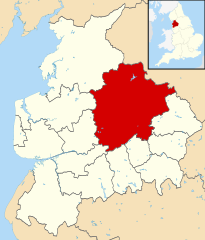
| Położenie na mapie Lancashire Contains Ordnance Survey data © Crown copyright and database right, CC BY-SA 3.0 | |
| Strona internetowa | |
| Portal | |
Ribble Valley – dystrykt w hrabstwie Lancashire w Anglii.
Miasta
Inne miejscowości
Aighton, Bailey and Chaigley, Balderstone, Barrow, Bashall Eaves, Billington, Bolton-by-Bowland, Brockhall Village, Chatburn, Chipping, Clayton-le-Dale, Copster Green, Dinckley, Downham, Easington, Gisburn, Great Mitton, Grindleton, Horton, Hothersall, Hurst Green, Langho, Little Mitton, Mellor, Newsholme, Newton, Osbaldeston, Paythorne, Pendleton, Read, Ribchester, Rimington, Sabden, Salesbury, Sawley, Simonstone, Slaidburn, Stopper Lane, Twiston, Waddington, West Bradford, Whalley, Whitewell, Wilpshire, Wiswell, Worston, York.
Przypisy
- ↑ Population Estimates for UK, England and Wales, Scotland and Northern Ireland - Office for National Statistics, www.ons.gov.uk [dostęp 2017-10-21] (ang.).
Media użyte na tej stronie
Flag of England. Saint George's cross (a red cross on a white background), used as the Flag of England, the Italian city of Genoa and various other places.
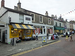
Autor: Photograph by Clem Rutter, Rochester, Kent. (www.clemrutter.net)., Licencja: CC BY-SA 3.0
Taken during a photoblitz on the streets in Clitheroe while attending the Wikimedia editathon at Clitheroe Castle Museum.
| Pozycja fotografa |
|
To i inne zdjęcia na: OpenStreetMap |
|
|---|
Contains Ordnance Survey data © Crown copyright and database right, CC BY-SA 3.0
Map of Lancashire, UK with Ribble Valley highlighted.
Equirectangular map projection on WGS 84 datum, with N/S stretched 165%


