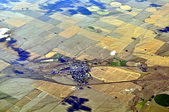
Ritzville
| ||
(c) Joe Mabel, CC BY-SA 3.0 Ritzville z lotu ptaka | ||
| Państwo | ||
| Stan | ||
| Hrabstwo | Adams | |
| Powierzchnia | 4,4[1] km² | |
| Populacja (2010) • liczba ludności • gęstość | 1673[2] 380,2 os./km² | |
| Nr kierunkowy | 509 | |
| Kod pocztowy | 99169 | |
| Strona internetowa | ||
| Portal | ||
Ritzville – miasto (city), ośrodek administracyjny hrabstwa Adams, we wschodniej części stanu Waszyngton, w Stanach Zjednoczonych. W 2010 roku miasto liczyło 1673 mieszkańców[2].
Pierwszym osadnikiem był Philip Ritz, który osiadł tu w 1878 roku. W 1881 roku dotarła tutaj linia kolejowa Northern Pacific Railway, stymulując rozwój osady. Miasto rozwinęło się głównie dzięki przemysłowi młynarskiemu, opierającemu się na uprawianej w regionie pszenicy[3].
Dzielnica śródmiejska, obejmująca m.in. kino i bibliotekę Carnegie, wpisana została w 1990 roku do Narodowego Rejestru Miejsc Historycznych[3].
Przypisy
- ↑ 2015 U.S. Gazetteer Files: Places: Washington (ang.). US Census Bureau. [dostęp 2017-06-18].
- ↑ a b Ritzville city, Washington (ang.). American FactFinder – US Census Bureau. [dostęp 2017-06-18]. [zarchiwizowane z tego adresu (2015-01-18)].
- ↑ a b Ritzville, Washington (ang.). Go Northwest!. [dostęp 2017-06-18].
Media użyte na tej stronie
Autor: Uwe Dedering, Licencja: CC BY-SA 3.0
Location map of the USA (without Hawaii and Alaska).
EquiDistantConicProjection:
Central parallel:
* N: 37.0° N
Central meridian:
* E: 96.0° W
Standard parallels:
* 1: 32.0° N
* 2: 42.0° N
Made with Natural Earth. Free vector and raster map data @ naturalearthdata.com.
Formulas for x and y:
x = 50.0 + 124.03149777329222 * ((1.9694462586094064-({{{2}}}* pi / 180))
      * sin(0.6010514667026994 * ({{{3}}} + 96) * pi / 180))
y = 50.0 + 1.6155950752393982 * 124.03149777329222 * 0.02613325650382181
      - 1.6155950752393982  * 124.03149777329222 *
     (1.3236744353715044  - (1.9694462586094064-({{{2}}}* pi / 180))
      * cos(0.6010514667026994 * ({{{3}}} + 96) * pi / 180))
The flag of Navassa Island is simply the United States flag. It does not have a "local" flag or "unofficial" flag; it is an uninhabited island. The version with a profile view was based on Flags of the World and as a fictional design has no status warranting a place on any Wiki. It was made up by a random person with no connection to the island, it has never flown on the island, and it has never received any sort of recognition or validation by any authority. The person quoted on that page has no authority to bestow a flag, "unofficial" or otherwise, on the island.
(c) Joe Mabel, CC BY-SA 3.0
Aerial view of Ritzville, Washington, U.S.
Autor: Alexrk2, Licencja: CC BY 3.0
Ta mapa została stworzona za pomocą GeoTools.


