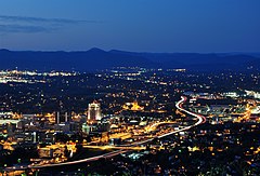
Roanoke (Wirginia)
(c) Joe Ravi, CC BY-SA 3.0 | |
| Państwo | |
|---|---|
| Stan | |
| Burmistrz | David A. Bowers |
| Powierzchnia | 111,4 km² |
| Wysokość | 269-530 m n.p.m. |
| Populacja (2018) • liczba ludności |
|
| Nr kierunkowy | 540 |
| Strona internetowa | |
| Portal | |
Roanoke – miasto w Stanach Zjednoczonych, w zachodniej części stanu Wirginia, nad rzeką Roanoke. Miasto właściwe ma 99 920 mieszkańców (dane z 2018), a jego obszar metropolitalny około 293 tys. (szacunek na 2005).
W mieście rozwinął się przemysł meblarski, chemiczny, samochodowy oraz metalowy[1].
Demografia
Miasta partnerskie
 Florianópolis, Brazylia
 Kisumu, Kenia
 Lijiang, Chińska Republika Ludowa
 Psków, Rosja
 Saint-Lô, Francja
 Wonju, Korea Południowa
 Opole, Polska
Przypisy
- ↑ Roanoke, [w:] Encyklopedia PWN [online] [dostęp 2021-08-08].
- ↑ Population and Housing Unit Estimates [zarchiwizowane z adresu 2019-07-31] (ang.).
- ↑ Census of Population and Housing, Census.gov [zarchiwizowane z adresu] (ang.).
Linki zewnętrzne
- Roanoke (Star City). roanoke-starcity.tripod.com. [zarchiwizowane z tego adresu (2011-07-17)]. (ang.)
Media użyte na tej stronie
Autor: Uwe Dedering, Licencja: CC BY-SA 3.0
Location map of the USA (without Hawaii and Alaska).
EquiDistantConicProjection:
Central parallel:
* N: 37.0° N
Central meridian:
* E: 96.0° W
Standard parallels:
* 1: 32.0° N
* 2: 42.0° N
Made with Natural Earth. Free vector and raster map data @ naturalearthdata.com.
Formulas for x and y:
x = 50.0 + 124.03149777329222 * ((1.9694462586094064-({{{2}}}* pi / 180))
      * sin(0.6010514667026994 * ({{{3}}} + 96) * pi / 180))
y = 50.0 + 1.6155950752393982 * 124.03149777329222 * 0.02613325650382181
      - 1.6155950752393982  * 124.03149777329222 *
     (1.3236744353715044  - (1.9694462586094064-({{{2}}}* pi / 180))
      * cos(0.6010514667026994 * ({{{3}}} + 96) * pi / 180))
The flag of Navassa Island is simply the United States flag. It does not have a "local" flag or "unofficial" flag; it is an uninhabited island. The version with a profile view was based on Flags of the World and as a fictional design has no status warranting a place on any Wiki. It was made up by a random person with no connection to the island, it has never flown on the island, and it has never received any sort of recognition or validation by any authority. The person quoted on that page has no authority to bestow a flag, "unofficial" or otherwise, on the island.
(c) Joe Ravi, CC BY-SA 3.0
Roanoke City as seen from Mill Mountain Star at dusk in Virginia, USA.
Autor: Ben Schumin, Licencja: CC BY-SA 2.5
Roanoke, Virginia as seen at night from the Mill Mountain Star. Photo by Ben Schumin on March 14, 2003.


