Rochford (dystrykt)
| dystrykt niemetropolitalny | |
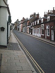
(c) John Myers, CC BY-SA 2.0 Rochford | |
| Państwo | |
|---|---|
| Kraj | |
| Region | |
| Hrabstwo | |
| Siedziba | |
| Powierzchnia | 169,49 km² |
| Populacja (2011) • liczba ludności |
|
| • gęstość | 169,49 os./km² |
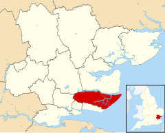
| Położenie na mapie Essex Contains Ordnance Survey data © Crown copyright and database right, CC BY-SA 3.0 | |
| Strona internetowa | |
| Portal | |
Rochford – dystrykt w hrabstwie Essex w Anglii.
W 2011 roku dystrykt liczył 83 287 mieszkańców[1].
Podział administracyjny
- Ashingdon
- Barling Magna
- Canewdon
- Foulness
- Great Wakering
- Hawkwell
- Hockley
- Hullbridge
- Paglesham
- Rawreth
- Rayleigh
- Rochford
- Stambridge
- Sutton
Inne miejscowości:
- Great Stambridge
- Little Stambridge
- Little Wakering
- Shopland
- Stonebridge
Przypisy
- ↑ Rochford (Local Authority). [w:] Neighbourhood Statistics • 2011 Census: Key Statistics [on-line]. Office for National Statistics. [dostęp 2013-11-17]. [zarchiwizowane z tego adresu (2015-06-10)]. (ang.).
- ↑ Rochford (Non-Metropolitan District). [w:] Neighbourhood Statistics • Full dataset view [on-line]. Office for National Statistics. [dostęp 2013-11-17]. [zarchiwizowane z tego adresu (2015-06-10)]. (ang.).
Linki zewnętrzne
- Home. Rochford District Council. [dostęp 2013-11-17]. (ang.).
Kontrola autorytatywna (non-metropolitan district):
Media użyte na tej stronie
Flag of England.svg
Flag of England. Saint George's cross (a red cross on a white background), used as the Flag of England, the Italian city of Genoa and various other places.
Flag of England. Saint George's cross (a red cross on a white background), used as the Flag of England, the Italian city of Genoa and various other places.
West Street, Rochford - geograph.org.uk - 222151.jpg
(c) John Myers, CC BY-SA 2.0
West Street, Rochford. The "High Street" by any other name. Most of the town's shops are in this road and the market square at the top.
(c) John Myers, CC BY-SA 2.0
West Street, Rochford. The "High Street" by any other name. Most of the town's shops are in this road and the market square at the top.
Rochford UK locator map.svg
Contains Ordnance Survey data © Crown copyright and database right, CC BY-SA 3.0
Equirectangular map projection on WGS 84 datum, with N/S stretched 160%
Contains Ordnance Survey data © Crown copyright and database right, CC BY-SA 3.0
Equirectangular map projection on WGS 84 datum, with N/S stretched 160%


