Romford
 | |
| Państwo | |
|---|---|
| Kraj | |
| Hrabstwo | |
| Populacja (2011) • liczba ludności |
|
Położenie na mapie Wielkiego Londynu  Contains Ordnance Survey data © Crown copyright and database right, CC BY-SA 3.0 | |
Położenie na mapie Wielkiej Brytanii  (c) Karte: NordNordWest, Lizenz: Creative Commons by-sa-3.0 de | |
Położenie na mapie Anglii  | |
| 51°34′36″N 0°10′48″E/51,576800 0,180100 | |
| Portal | |
Romford – miasto na wschodzie Londynu, leżące w gminie London Borough of Havering[1]. W 2011 miasto liczyło 95894 mieszkańców[2].
Galeria
 (c) Lobster1, CC BY-SA 3.0
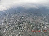
Widok na miasto z góry
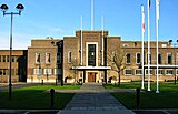
Ratusz

Wejście do stacji kolejowej

Mapa pobliskich miejscowości
Przypisy
- ↑ Photos near Romford/TQ5289 :: Geograph Britain and Ireland, www.geograph.org.uk [dostęp 2017-11-20] (ang.).
- ↑ Local statistics - Office for National Statistics, www.neighbourhood.statistics.gov.uk [dostęp 2017-11-20] [zarchiwizowane z adresu 2016-03-04] (ang.).
Linki zewnętrzne
Media użyte na tej stronie
Greater London UK location map 2.svg
Contains Ordnance Survey data © Crown copyright and database right, CC BY-SA 3.0
Contains Ordnance Survey data © Crown copyright and database right, CC BY-SA 3.0
Map of Greater London, UK with the following information shown:
- Administrative borders
- Coastline, lakes and rivers
- Roads and railways
- Urban areas
The data includes both primary routes and railway lines.
Equirectangular map projection on WGS 84 datum, with N/S stretched 160%
Geographic limits:
- West: 0.57W
- East: 0.37E
- North: 51.72N
- South: 51.25N
United Kingdom adm location map.svg
(c) Karte: NordNordWest, Lizenz: Creative Commons by-sa-3.0 de
Location map of the United Kingdom
(c) Karte: NordNordWest, Lizenz: Creative Commons by-sa-3.0 de
Location map of the United Kingdom


Flag of England.svg
Flag of England. Saint George's cross (a red cross on a white background), used as the Flag of England, the Italian city of Genoa and various other places.
Flag of England. Saint George's cross (a red cross on a white background), used as the Flag of England, the Italian city of Genoa and various other places.
.jpg)

Romford 15 mile radius.png
Autor: CastleCapt, Licencja: CC BY-SA 4.0
15 mile radius circle map from Romford, England.
Autor: CastleCapt, Licencja: CC BY-SA 4.0
15 mile radius circle map from Romford, England.
Havering romford welcome sign.jpg
Autor: MRSC, Licencja: CC BY-SA 4.0
Havering/Romford welcome sign at Roneo Corner
Autor: MRSC, Licencja: CC BY-SA 4.0
Havering/Romford welcome sign at Roneo Corner

Havering town hall london.jpg
Town Hall of Havering London Borough Council.
Town Hall of Havering London Borough Council.

Romford station entrance.JPG
Autor: Sunil060902, Licencja: CC BY-SA 3.0
Romford station entrance, on South Street, roughly opposite the former entrance to the bay part of the station (opened by the London, Tilbury & Southend Railway), now used as a bar. This part of the station is the original 1839 Great Eastern station.
Autor: Sunil060902, Licencja: CC BY-SA 3.0
Romford station entrance, on South Street, roughly opposite the former entrance to the bay part of the station (opened by the London, Tilbury & Southend Railway), now used as a bar. This part of the station is the original 1839 Great Eastern station.