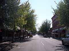
Roseburg (Oregon)
| ||||
| ||||
 | ||||
| Państwo | ||||
| Stan | ||||
| Hrabstwo | Douglas | |||
| Data założenia | 1872 | |||
| Kod statystyczny | FIPS: 41-63650 GNIS ID: 1126298 | |||
| Zarządzający | Larry Rich | |||
| Powierzchnia | 26,42 km² | |||
| Wysokość | 161 m n.p.m. | |||
| Populacja (2013) • liczba ludności • gęstość | 21 968 847 os./km² | |||
| Nr kierunkowy | 541 | |||
| Kod pocztowy | 97470, 97471 | |||
| Strefa czasowa | UTC-08:00 UTC-07:00 | |||
| Strona internetowa | ||||
| Portal | ||||
Roseburg – miasto w Stanach Zjednoczonych. Położone nad rzeką Umpqua w południowo-zachodniej części stanu Oregon. Siedziba administracyjna i najludniejsze miasto hrabstwa Douglas. W roku 2013 zamieszkiwane przez 21 968 mieszkańców[1].
Ludzie związani z Roseburgiem
- John Kitzhaber – polityk, gubernator stanu Oregon 1995-2003, 2011-2015
- Joseph Lane – generał, pierwszy gubernator stanu Oregon
- Johnnie Ray – piosenkarz
- Chris Thompson – pływak, brązowy medalista na Igrzyskach Olimpijskich w 2000 r. w Sydney
Miasta partnerskie
 Aranda de Duero, Kastylia i León, Hiszpania
 Shōbu, Japonia
Linki zewnętrzne
Przypisy
- ↑ Roseburg, Oregon (ang.). City-Data.com. [dostęp 2015-10-02].
Media użyte na tej stronie
Autor: Uwe Dedering, Licencja: CC BY-SA 3.0
Location map of the USA (without Hawaii and Alaska).
EquiDistantConicProjection:
Central parallel:
* N: 37.0° N
Central meridian:
* E: 96.0° W
Standard parallels:
* 1: 32.0° N
* 2: 42.0° N
Made with Natural Earth. Free vector and raster map data @ naturalearthdata.com.
Formulas for x and y:
x = 50.0 + 124.03149777329222 * ((1.9694462586094064-({{{2}}}* pi / 180))
      * sin(0.6010514667026994 * ({{{3}}} + 96) * pi / 180))
y = 50.0 + 1.6155950752393982 * 124.03149777329222 * 0.02613325650382181
      - 1.6155950752393982  * 124.03149777329222 *
     (1.3236744353715044  - (1.9694462586094064-({{{2}}}* pi / 180))
      * cos(0.6010514667026994 * ({{{3}}} + 96) * pi / 180))
The flag of Navassa Island is simply the United States flag. It does not have a "local" flag or "unofficial" flag; it is an uninhabited island. The version with a profile view was based on Flags of the World and as a fictional design has no status warranting a place on any Wiki. It was made up by a random person with no connection to the island, it has never flown on the island, and it has never received any sort of recognition or validation by any authority. The person quoted on that page has no authority to bestow a flag, "unofficial" or otherwise, on the island.
Autor: Pedro A. Gracia Fajardo, escudo de Manual de Imagen Institucional de la Administración General del Estado, Licencja: CC0
Flaga Hiszpanii
Autor: Visitor7, Licencja: CC BY-SA 3.0
Roseburg High School (Roseburg, Oregon)
Flag of Oregon (obverse): The flag was adopted by the state on February 26, 1925.[1] The state seal was decided in 1903.[2][3]
Autor: Alexrk2, Licencja: CC BY 3.0
Ta mapa została stworzona za pomocą GeoTools.
Autor: Rytyho usa, Licencja: CC BY-SA 3.0
This is Mercy Medical Center, a hospital located in Roseburg, Oregon, USA.


