Rostherne
| Ten artykuł od 2011-11 wymaga zweryfikowania podanych informacji. |
| ||
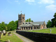
(c) Simon Huguet, CC BY-SA 2.0 | ||
| Państwo | ||
| Kraj | ||
| Hrabstwo ceremonialne | Cheshire | |
| Unitary authority | Cheshire East | |
| Nr kierunkowy | 01565 | |
| Kod pocztowy | WA16 | |
Położenie na mapie Cheshire Contains Ordnance Survey data © Crown copyright and database right, CC BY-SA 3.0 | ||
Położenie na mapie Wielkiej Brytanii (c) Karte: NordNordWest, Lizenz: Creative Commons by-sa-3.0 de | ||
| Portal | ||
Rostherne – wieś w Anglii, w hrabstwie ceremonialnym Cheshire, w dystrykcie (unitary authority) Cheshire East.
Media użyte na tej stronie
(c) Karte: NordNordWest, Lizenz: Creative Commons by-sa-3.0 de
Location map of the United Kingdom
Flag of England. Saint George's cross (a red cross on a white background), used as the Flag of England, the Italian city of Genoa and various other places.
Contains Ordnance Survey data © Crown copyright and database right, CC BY-SA 3.0
Map of Cheshire, UK with the following information shown:
- Administrative borders
- Coastline, lakes and rivers
- Roads and railways
- Urban areas
Equirectangular map projection on WGS 84 datum, with N/S stretched 165%
Geographic limits:
- West: 3.15W
- East: 1.95W
- North: 53.50N
- South: 52.94N
(c) Simon Huguet, CC BY-SA 2.0
St Mary, Rostherne The parish church for the Tatton Estate village of Rostherne. The churchyard is slightly strange because all of the old memorials near to the church have been laid flat making it look a bit like a car park!


