Rozendaal
| |||||
 Zamek w Rozendaal | |||||
| |||||
| Państwo | |||||
| Prowincja | Geldria | ||||
| Gmina | Rozendaal | ||||
| Burmistrz | Ester Weststeijn-Vermaat | ||||
| Powierzchnia | 27,95 km² | ||||
| Populacja (1 marca 2013) • liczba ludności • gęstość | 1 507[1] 54 osób os./km² | ||||
| Nr kierunkowy | 026 | ||||
| Kod pocztowy | 6891 | ||||
 | |||||
| Strona internetowa | |||||
Rozendaal – miasto i gmina w prowincji Geldria w Holandii. Miasto liczy 1 507 mieszkańców (spis z 1 marca 2013) i ma powierzchnię 27,95 km² (z czego 0,03 km² stanowią wody). Gmina Rozendaal jest częścią aglomeracji Arnhem-Nijmegen.
Rozendaal jest jedną z najmniejszych gmin pod względem ludności w Holandii. Tylko Vlieland i Schiermonnikoog mają mniej mieszkańców.
Skład gminy
Oprócz Rozendaal w skład gminy o tej samej nazwie wchodzą dwie wioski:
- Imbosch
- Terlet
Ludność
Rozendaal liczy 1 507 mieszkańców, a gęstość zaludnienia wynosi 54 osób na km².
Zabytki
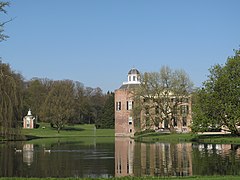
- Zamek (nl. Kasteel Rosendael) – rezydencja hrabiów i książąt Geldrii, wzmiankowany po raz pierwszy w 1314, od 1516 kolejno własność rodzin van Dörth, Van Arnhem, Torck i Pallandt. Od 1977 w posiadaniu fundacji Stichting Vrienden der Geldersche Kasteelen[2]. Odrestaurowany w latach 80. i udostępniony dla zwiedzających w 1990[3][4]. Zamek otacza park zaprojektowany przez Daniela Marot w XVII wieku w stylu francuskim i zmodernizowany w 1837 w stylu angielskim wg projektu Jana Davida Zochera jr.[4]
- Kapelleberg
Przypisy
- ↑ Centraal Bureau voor de Statistiek: strona oficjalna (niderl.). W: Bevolkingsontwikkeling; regio per maand [on-line]. [dostęp 2013-05-26].
- ↑ Geldersch Landschap & Kasteelen: Kasteel Rosendael: Geschiedenis (niderl.). [dostęp 2013-05-26].
- ↑ Rozendaal: strona oficjalna (niderl.). W: Historie van de gemeente Rozendaal [on-line]. [dostęp 2013-05-26]. [zarchiwizowane z tego adresu (2013-09-28)].
- ↑ a b Geldersch Landschap & Kasteelen: Welkom op park Rosendael (niderl.). W: Historie van de gemeente Rozendaal [on-line]. [dostęp 2013-05-26].
Media użyte na tej stronie
Autor: Erik Frohne, Licencja: CC BY-SA 3.0
Location map of province Gelderland in the Netherlands
Equirectangular projection, N/S stretching 163 %. Geographic limits of the map:
- N: 52.522° N
- S: 51.731° N
- W: 4.989° E
- E: 6.834° E
Autor: Michielverbeek, Licencja: CC BY-SA 3.0
To jest zdjęcie holenderskiego zabytku (rijksmonument) numer 528472
Coat of arms of Rozendaal.
Autor: Michiel1972 (talk) 22:10, 24 January 2009 (UTC), Licencja: CC BY-SA 3.0
- Location maps for the 441 municipalities in the Netherlands. Boundaries 1/1/2009
- Automatically generated with script
- File name contains "Municipality code" (CBS-code) as specified in: [1]
- Created in svg using coordinate data derived from ESRI data published by Centraal Bureau voor de Statistiek, Voorburg/Heerlen. ([2])
- Color coding and original design (slightly adpated by me) by user Mtcv (2006/2007) ([3])
 |
Właściciel autorskich praw majątkowych do tego pliku, Centraal Bureau voor de Statistiek, zezwala każdemu wykorzystać go w dowolnym celu, pod warunkiem, że wykorzystujący wyraźnie wskaże autora. Redystrybucja, wykonywanie prac pochodnych, użycie komercyjne oraz każde inne są dozwolone. |
|
Uznanie autorstwa: Centraal Bureau voor de Statistiek
|
Autor: Tom Ordelman (Thor NL), Licencja: CC-BY-SA-3.0
360° panoramic picture of Rosendael Castle in the village of Rozendaal, near the city of Arnhem in the Netherlands.
Flag of Rozendaal Netherlands


