Rugby (borough)
| ||||
| ||||
 Siedziba władz dystryktu | ||||
| Państwo | ||||
| Kraj | ||||
| Region | West Midlands | |||
| Hrabstwo | Warwickshire | |||
| Siedziba | Rugby | |||
| Powierzchnia | 351,1 km² | |||
| Populacja (2011) • liczba ludności | 100 075 | |||
| • gęstość | 290 os./km² | |||
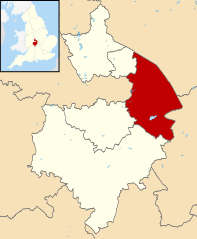
Położenie na mapie Warwickshire | ||||
| Strona internetowa | ||||
| Portal | ||||
Rugby – dystrykt o statusie borough w hrabstwie Warwickshire w Anglii. W 2011 roku dystrykt liczył 100 075 mieszkańców[1].
Miasta
Inne miejscowości
Ansty, Bilton, Binley Woods, Birdingbury, Bourton-on-Dunsmore, Brandon, Bretford, Brinklow, Broadwell, Brownsover, Cathiron, Cawston, Church Lawford, Churchover, Clifton upon Dunsmore, Copston Magna, Cosford, Draycote, Dunchurch, Easenhall, Flecknoe, Frankton, Grandborough, Harborough Magna, Hill, Hillmorton, Kites Hardwick, Leamington Hastings, Little Lawford, Long Lawford, Marton, Monks Kirby, New Bilton, Newbold-on-Avon, Newton, Pailton, Princethorpe, Ryton-on-Dunsmore, Sawbridge, Shilton, Street Ashton, Stretton-on-Dunsmore, Stretton under Fosse, Thurlaston, Wibtoft, Willey, Willoughby, Withybrook, Wolston, Wolvey.
Przypisy
- ↑ Area: Rugby (Local Authority) (ang.). Neighbourhood Statistics (ONS). [dostęp 2016-04-17]. [zarchiwizowane z tego adresu (2016-09-27)].
Media użyte na tej stronie
Flag of England. Saint George's cross (a red cross on a white background), used as the Flag of England, the Italian city of Genoa and various other places.
Autor:
- Warwickshire UK district map (blank).svg: Nilfanion, created using Ordnance Survey data
- derivative work: Renly (talk)
Map of Warwickshire, with Rugby highlighted.
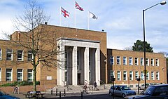
Rugby town hall in Rugby town centre, in Warwickshire, England. The hall is the headquarters of Rugby Borough Council, and was opened in 1961.
The earlier town hall in the High Street is now a Marks and Spencers shop.
Photo by G-Man April 2005


