Rungsted Kyst
| ||
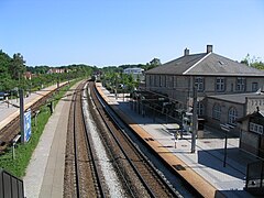
 Widok na stację | ||
| Państwo | ||
| Miejscowość | Rungsted | |
| Lokalizacja | Vestre Stationsvej 7[1] | |
| Zarządca | Danske Statsbaner | |
| Data otwarcia | 1897 | |
| Dane techniczne | ||
| Liczba peronów | 3 | |
| Liczba krawędzi peronowych | 3 | |
| Kasy | ||
| Linie kolejowe | ||
| ||
| Portal | ||
Rungsted Kyst (duń. Rungsted Kyst Station) – stacja kolejowa w miejscowości Rungsted, w Regionie Stołecznym, w Danii. Znajduje się na linii Kystbanen.
Obsługiwana jest przez pociągi regionalne.
Budynek dworca został zbudowany w 1897 roku. Podobnie jak inne stacje na linii Øresund, został zaprojektowany przez Heinricha Wenck. Obecnie jest obiektem zabytkowym[2].
Linie kolejowe
- Kystbanen
Przypisy
- ↑ Rungsted Kyst Station (duń.). krak.dk. [dostęp 2015-11-07].
- ↑ "Sag: Rungsted Kyst Station" (duń.). Kulturstyrelsen. [dostęp 2016-11-07].
Linki zewnętrzne
| Rungsted Kyst | ||
| Linia Kystbanen | ||
Media użyte na tej stronie
Autor: Erik Frohne, Licencja: CC BY-SA 3.0
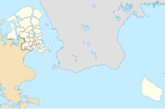
Location map of the Capital Region in Denmark, color adjusted
Equirectangular projection, N/S stretching 177 %. Geographic limits of the map:
- N: 56.20° N
- S: 54.90° N
- W: 11.70° E
- E: 15.20° E
Autor: MGalloway (WMF), Licencja: CC BY-SA 3.0
A tickmark icon included in the OOjs UI MediaWiki lib.
Autor: MGalloway (WMF), Licencja: CC BY-SA 3.0
A tickmark icon included in the OOjs UI MediaWiki lib.
head station, track to the left
head station, track to the left
Straight line aqross (according to naming convention, name + modifier)
station at track aqross
head station, track to the right
head station, track to the right
Rungsted Stasjon


