Rutland
| Hrabstwo ceremonialne i unitary authority | |||||
(c) Mat Fascione, CC BY-SA 2.0 Wybrzeże jeziora Rutland Water | |||||
| |||||
| Państwo | |||||
|---|---|---|---|---|---|
| Kraj | |||||
| Region | |||||
| Siedziba | |||||
| Powierzchnia | 382 km² | ||||
| Populacja (2016) • liczba ludności |
| ||||
| • gęstość | 101 os./km² | ||||
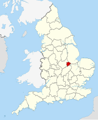
Położenie na mapie | |||||
| Strona internetowa | |||||
| Portal | |||||
Rutland – hrabstwo ceremonialne i historyczne oraz jednostka administracyjna typu unitary authority w środkowej Anglii, w regionie East Midlands.
Powierzchnia hrabstwa wynosi 382 km², a liczba ludności – 38 606 (2016)[1]. Rutland jest najmniejszym spośród historycznych hrabstw Anglii oraz jednym z najmniejszych hrabstw ceremonialnych (mniejsze są tylko City of London, City of Bristol oraz Isle of Wight). Na terenie hrabstwa znajdują się dwa miasta – Oakham, będące ośrodkiem administracyjnym, oraz Uppingham.
Hrabstwo ma charakter wiejski, a w przeszłości na jego obszarze znajdował się słabo zaludniony las dębowy. Pierwsza wzmianka o Rutland jako samodzielnym hrabstwie pochodzi z 1159 roku.
W środkowej części hrabstwa znajduje się Rutland Water, największe pod względem powierzchni sztuczne jezioro w Anglii, zbudowane w latach 70. XX wieku.
Rutland graniczy z hrabstwem Leicestershire na zachodzie i północnym zachodzie, z Lincolnshire na wschodzie i północnym wschodzie oraz z Northamptonshire na południu.
Mapa
Przypisy
- ↑ a b Population Estimates for UK, England and Wales, Scotland and Northern Ireland - Office for National Statistics, www.ons.gov.uk [dostęp 2017-10-22] (ang.).
- ↑ Office for National Statistics: KS101EW - Usual resident population. [w:] 2011 Census [on-line]. Nomis – Official labour market statistics, 2013-02-12. [dostęp 2022-06-05]. (ang.).
- ↑ Office for National Statistics: Built-up Area to Local Authority District (December 2011) Lookup in England and Wales. [w:] Open Geography Portal [on-line]. [dostęp 2022-06-05]. (ang.).
- ↑ Office for National Statistics: Built-up Area Sub Divisions (December 2011) Boundaries. [w:] Open Geography Potal [on-line]. [dostęp 2022-06-05]. (ang.).
Bibliografia
- Rutland, [w:] Encyclopædia Britannica [online] [dostęp 2011-12-05] (ang.).
Media użyte na tej stronie
Flag of England. Saint George's cross (a red cross on a white background), used as the Flag of England, the Italian city of Genoa and various other places.
Autor: Nilfanion, Licencja: CC BY-SA 3.0
Location of the ceremonial county of Rutland within England.
Autor:
- Flag_of_Rutland.jpg: en:User:Vexilo
- derivative work: NikNaks93 (talk)
Flag of Rutland
Contains Ordnance Survey data © Crown copyright and database right, CC BY-SA 3.0
Map of Rutland, UK with the following information shown:
- Administrative borders
- Coastline, lakes and rivers
- Roads and railways
- Urban areas
Equirectangular map projection on WGS 84 datum, with N/S stretched 160%
Geographic limits:
- West: 0.85W
- East: 0.35W
- North: 52.77N
- South: 52.52N
(c) Mat Fascione, CC BY-SA 2.0
The south shore of the Hambleton Peninsula Part of England's largest reservoir.


