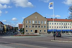
Säffle
 | |||
| |||
| Państwo | |||
|---|---|---|---|
| Region | |||
| Gmina | |||
| Powierzchnia | 8,17[1] km² | ||
| Populacja (2018) • liczba ludności • gęstość | |||
| Portal | |||
Säffle - miejscowość (tätort) i siedziba gminy Säffle w południowej Szwecji, w regionie Värmland.
W styczniu 2012 liczyło 8 994 mieszkańców[2].
Przypisy
- ↑ a b c Statistiska tätorter 2018; befolkning, landareal, befolkningstäthet (szw.). Statistikmyndigheten SCB, 2020-03-20. [dostęp 2020-09-08]. [zarchiwizowane z tego adresu (2020-03-24)].
- ↑ - World Gazetteer (ang.)
Media użyte na tej stronie
(c) Lokal_Profil, CC BY-SA 2.5
This coat of arms was drawn based on its blazon which – being a written description – is free from copyright. Any illustration conforming with the blazon of the arms is considered to be heraldically correct. Thus several different artistic interpretations of the same coat of arms can exist. The design officially used by the armiger is likely protected by copyright, in which case it cannot be used here.
Individual representations of a coat of arms, drawn from a blazon, may have a copyright belonging to the artist, but are not necessarily derivative works.
Autor: Mattias Ivermark, Licencja: CC BY-SA 3.0
Säffle stadshus från öster. Till höger skymtas Kanaltorget och gatan till vänster i bild är Västra Storgatan.
(c) Lokal_Profil, CC BY-SA 2.5
This coat of arms was drawn based on its blazon which – being a written description – is free from copyright. Any illustration conforming with the blazon of the arms is considered to be heraldically correct. Thus several different artistic interpretations of the same coat of arms can exist. The design officially used by the armiger is likely protected by copyright, in which case it cannot be used here.
Individual representations of a coat of arms, drawn from a blazon, may have a copyright belonging to the artist, but are not necessarily derivative works.
Autor: Erik Frohne, Licencja: CC BY 3.0
Location map of Värmland in Sweden
Equirectangular projection, N/S stretching 199 %. Geographic limits of the map:
- N: 61.20° N
- S: 58.60° N
- W: 11.60° E
- E: 14.70° E


