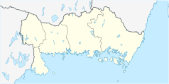
Sölvesborg
| |||
 | |||
| |||
| Państwo | |||
| Region | Blekinge | ||
| Gmina | Sölvesborg | ||
| Powierzchnia | 7,24[1] km² | ||
| Populacja (2018) • liczba ludności • gęstość | 8894[1] 1229[1] os./km² | ||
| Portal | |||
Sölvesborg – miejscowość (tätort) w Szwecji, w regionie administracyjnym (län) Blekinge, w gminie Sölvesborg.
Według danych Szwedzkiego Urzędu Statystycznego liczba ludności wyniosła: 8972 (31 grudnia 2015), 8894 (31 grudnia 2018) i 8870 (31 grudnia 2019)[1].
Miasta partnerskie
Przypisy
- ↑ a b c d Statistiska tätorter 2018; befolkning, landareal, befolkningstäthet (szw.). Statistikmyndigheten SCB, 2020-03-20. [dostęp 2020-09-08]. [zarchiwizowane z tego adresu (2020-03-24)].
Linki zewnętrzne
- Oficjalna strona miasta (szw.)
Media użyte na tej stronie
(c) Henrik Sendelbach, CC BY-SA 3.0
The sculpture "Ask och Embla" (Ask and Embla) by Stig Blomberg 1948, Sölvesborg, Sweden
(c) Lokal_Profil, CC BY-SA 2.5
This coat of arms was drawn based on its blazon which – being a written description – is free from copyright. Any illustration conforming with the blazon of the arms is considered to be heraldically correct. Thus several different artistic interpretations of the same coat of arms can exist. The design officially used by the armiger is likely protected by copyright, in which case it cannot be used here.
Individual representations of a coat of arms, drawn from a blazon, may have a copyright belonging to the artist, but are not necessarily derivative works.
Autor: Erik Frohne, Licencja: CC BY 3.0
Location map of Blekinge County in Sweden
Equirectangular projection, N/S stretching 182 %. Geographic limits of the map:
- N: 56° 33' N
- S: 55° 56' N
- W: 14° 08' E
- E: 16° 23' E


