Słochynie (przystanek kolejowy)
| ||
| Państwo | ||
|---|---|---|
| Miejscowość | Słochynie | |
| Dane techniczne | ||
| Liczba peronów | 1 | |
| Liczba krawędzi peronowych | 1 | |
| Linie kolejowe | ||
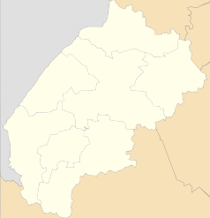
Położenie na mapie Ukrainy (c) Karte: NordNordWest, Lizenz: Creative Commons by-sa-3.0 de | ||
| Portal | ||
Słochynie (ukr. Слохиня, ros. Слохиня) – przystanek kolejowy w miejscowości Słochynie, w rejonie starosamborskim, w obwodzie lwowskim, na Ukrainie.
Bibliografia
| Słochynie | ||
| Linia Sambor – Starzawa (24,0 km) | ||
odległość: 3,0 km | odległość: 2,0 km | |
| Linia Chyrów Posada – Słochynie | ||
Media użyte na tej stronie
Lviv Oblast location map.svg
Autor: RosssW, Licencja: CC BY-SA 4.0
Районы Львовской области с 17 июля 2020 года.
Autor: RosssW, Licencja: CC BY-SA 4.0
Районы Львовской области с 17 июля 2020 года.
Ukraine adm location map.svg
(c) Karte: NordNordWest, Lizenz: Creative Commons by-sa-3.0 de
Location map of Ukraine
(c) Karte: NordNordWest, Lizenz: Creative Commons by-sa-3.0 de
Location map of Ukraine
BSicon KBHFl.svg
head station, track to the left
head station, track to the left
BSicon KBHFaq.svg
head station, track to the left
head station, track to the left
BSicon STRq.svg
Straight line aqross (according to naming convention, name + modifier)
Straight line aqross (according to naming convention, name + modifier)
BSicon BHFq.svg
station at track aqross
station at track aqross
BSicon KBHFr.svg
head station, track to the right
head station, track to the right
BSicon KBHFeq.svg
head station, track to the right
head station, track to the right


