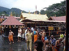
Sabarimala
| ||
| Państwo | ||
| Miejscowość | Stan Kerala | |
| Wyznanie | hinduizm | |
| Wezwanie | Ajjappan | |
Położenie na mapie Indii | ||
| Strona internetowa | ||
Świątynia Sabarimala – świątynia hinduistyczna w stanie Kerala, w Indiach. Uważana za jedno z najświętszych miejsc hinduizmu, cel corocznych pielgrzymek wyłącznie mężczyzn[1]. Do niedawna kobiety zwyczajowo nie miały wstępu na teren świątyni, lecz we wrześniu 2018 Sąd Najwyższy stwierdził, że zakaz jest niezgodny z konstytucją. Próby wejścia do świątyni przez osoby inne niż hinduscy mężczyźni doprowadziły do gwałtownych zamieszek[2][3].
Przypisy
- ↑ Sabarimala: Świątynia, w której kobiety nie są dozwolone!. Trip'n holidays. [dostęp 2018-11-05].
- ↑ Religion and Women’s Rights Clash, Violently, at a Shrine in India. The New York Times. [dostęp 2018-11-05].
- ↑ Kobiety chciały wejść do świątyni Sabarimala. Zaatakował je rozwścieczony tłum. Wprost. [dostęp 2018-11-05].
Media użyte na tej stronie
(c) Uwe Dedering z niemieckiej Wikipedii, CC BY-SA 3.0
Location map of India.
Equirectangular projection. Strechted by 106.0%. Geographic limits of the map:
- N: 37.5° N
- S: 5.0° N
- W: 67.0° E
- E: 99.0° E
The Flag of India. The colours are saffron, white and green. The navy blue wheel in the center of the flag has a diameter approximately the width of the white band and is called Ashoka's Dharma Chakra, with 24 spokes (after Ashoka, the Great). Each spoke depicts one hour of the day, portraying the prevalence of righteousness all 24 hours of it.
Autor: NordNordWest, Licencja: CC BY-SA 3.0 de
Location map of Kerala, India


