Saint-Dizier
| miejscowość i gmina | |||
.JPG) Saint-Dizier, 2011 | |||
| |||
| Państwo | |||
|---|---|---|---|
| Region | |||
| Departament | |||
| Okręg | |||
| Kod INSEE | 52448 | ||
| Powierzchnia | 47,66 km² | ||
| Populacja (1990) • liczba ludności |
| ||
| • gęstość | 704 os./km² | ||
| Kod pocztowy | 52100 | ||
Położenie na mapie Górnej Marny  | |||
Położenie na mapie Francji  | |||
Położenie na mapie regionu Grand Est  | |||
| Strona internetowa | |||
| Portal | |||
.svg)
Saint-Dizier – miejscowość i gmina we Francji, w regionie Grand Est, w departamencie Górna Marna.
Według danych na rok 1990 gminę zamieszkiwały 33 552 osoby, a gęstość zaludnienia wynosiła 704 os./km².
W Saint-Dizier zlokalizowana jest baza francuskiego lotnictwa wojskowego nr 113 Saint-Dizier-Robinson. Z uwagi na zatrudnianie ok. 1800 osób, w tym 1700 wojskowych, jest to jeden z głównych pracodawców w departamencie Górna Marna.
Galeria
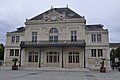
Teatr w Saint-Dizier, 2011

Dworzec kolejowy w Saint-Dizier, 2010

Zamek w Saint-Dizier, 2011
Bibliografia
- Francuski urząd statystyczny. (fr.).
Linki zewnętrzne
Media użyte na tej stronie
France location map-Regions and departements-2016.svg
Autor: Superbenjamin, Licencja: CC BY-SA 4.0
Blank administrative map of France for geo-location purpose, with regions and departements distinguished. Approximate scale : 1:3,000,000
Autor: Superbenjamin, Licencja: CC BY-SA 4.0
Blank administrative map of France for geo-location purpose, with regions and departements distinguished. Approximate scale : 1:3,000,000
Grand Est region location map.svg
Autor: Flappiefh, Licencja: CC BY-SA 4.0
Carte administrative vierge de la région Grand Est, France, destinée à la géolocalisation.
Autor: Flappiefh, Licencja: CC BY-SA 4.0
Carte administrative vierge de la région Grand Est, France, destinée à la géolocalisation.
.svg)
Saint Dizier (46).JPG
Autor: Prosopee, Licencja: CC BY 3.0
Saint Dizier (Haute-Marne, France). Rue Gambetta.
Autor: Prosopee, Licencja: CC BY 3.0
Saint Dizier (Haute-Marne, France). Rue Gambetta.

.JPG)
Saint Dizier (5).JPG
Autor: Prosopee, Licencja: CC BY 3.0
Autor: Prosopee, Licencja: CC BY 3.0
Saint Dizier.
Théâtre à l'italienne (vue générale)..JPG)
Saint Dizier (38).JPG
Autor: Prosopee, Licencja: CC BY 3.0
Château de Saint Dizier : enceinte du château fort avec les deux tours de la porte d'entrée et tour du St-Esprit. Inscription aux monuments historiques en 1994.
Autor: Prosopee, Licencja: CC BY 3.0
Château de Saint Dizier : enceinte du château fort avec les deux tours de la porte d'entrée et tour du St-Esprit. Inscription aux monuments historiques en 1994.
Haute-Marne department location map.svg
Autor: Flappiefh, Licencja: CC BY-SA 4.0
Blank administrative map of the department of Haute-Marne, France, for geo-location purpose.
Autor: Flappiefh, Licencja: CC BY-SA 4.0
Blank administrative map of the department of Haute-Marne, France, for geo-location purpose.