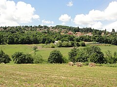
Saint-Genest-Lerpt
| miejscowość i gmina | |||
 Saint-Genest-Lerpt, 2010 | |||
| |||
| Państwo | |||
|---|---|---|---|
| Region | |||
| Departament | |||
| Okręg | |||
| Kod INSEE | 42223 | ||
| Powierzchnia | 12,69 km² | ||
| Populacja (1990) • liczba ludności |
| ||
| • gęstość | 432 os./km² | ||
| Kod pocztowy | 42530 | ||
| Strona internetowa | |||
| Portal | |||
Saint-Genest-Lerpt – miejscowość i gmina we Francji, w regionie Owernia-Rodan-Alpy, w departamencie Loara. Nazwa miejscowości pochodzi od imienia św. Genezjusza[1].
Według danych na rok 1990 gminę zamieszkiwały 5482 osoby, a gęstość zaludnienia wynosiła 432 os./km² (wśród 2880 gmin regionu Rodan-Alpy Saint-Genest-Lerpt plasuje się na 157. miejscu pod względem liczby ludności, natomiast pod względem powierzchni na miejscu 925.).
Populacja
Przypisy
- ↑ Longnon A., Les noms de lieu de la France; leur origine, leur signification, leurs transformations, Paryż 1973, ISBN 0-8337-2142-9
Bibliografia
- Francuski urząd statystyczny (fr.).
Linki zewnętrzne
Media użyte na tej stronie
Autor: Superbenjamin, Licencja: CC BY-SA 4.0
Blank administrative map of France for geo-location purpose, with regions and departements distinguished. Approximate scale : 1:3,000,000
Autor: Flappiefh, Licencja: CC BY-SA 4.0
Carte administrative vierge de la région Auvergne-Rhône-Alpes, France, destinée à la géolocalisation.
Autor: Michiel1972, Licencja: CC BY-SA 3.0
Population - Municipality code 42223.svg
Population Census 1962-2008Autor: Flappiefh, Licencja: CC BY-SA 4.0
Blank administrative map of the department of Loire, France, for geo-location purpose.
Autor: Bear17, Licencja: CC BY-SA 3.0
Blason de la commune de Saint-Genest-Lerpt
Extrémité nord de St-Genest Lerpt (Loire), quartier du Chasseur depuis route de Villars.


