Saint-Pantaléon-les-Vignes
| miejscowość i gmina | |||
 Saint-Pantaléon-les-Vignes, 2012 | |||
| |||
| Państwo | |||
|---|---|---|---|
| Region | |||
| Departament | |||
| Okręg | |||
| Kod INSEE | 26322 | ||
| Powierzchnia | 8,39 km² | ||
| Populacja (1990) • liczba ludności |
| ||
| • gęstość | 38 os./km² | ||
| Kod pocztowy | 26770 | ||
Położenie na mapie Drôme  | |||
Położenie na mapie Francji  | |||
Położenie na mapie regionu Owernia-Rodan-Alpy  | |||
| Portal | |||
Saint-Pantaléon-les-Vignes – miejscowość i gmina we Francji, w regionie Owernia-Rodan-Alpy, w departamencie Drôme.
Według danych na rok 1990 gminę zamieszkiwało 319 osób, a gęstość zaludnienia wynosiła 38 osób/km² (wśród 2880 gmin regionu Rodan-Alpy Saint-Pantaléon-les-Vignes plasuje się na 1311. miejscu pod względem liczby ludności, natomiast pod względem powierzchni na miejscu 1249.).
Galeria
Ratusz, 2012

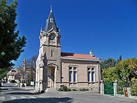
Kościół, 2012

Fontanna, 2012
Bibliografia
- Francuski urząd statystyczny. (fr.).
Media użyte na tej stronie
Drome department location map.svg
Autor: Flappiefh, Licencja: CC BY-SA 4.0
Blank administrative map of the department of Drôme, France, for geo-location purpose.
Autor: Flappiefh, Licencja: CC BY-SA 4.0
Blank administrative map of the department of Drôme, France, for geo-location purpose.
France location map-Regions and departements-2016.svg
Autor: Superbenjamin, Licencja: CC BY-SA 4.0
Blank administrative map of France for geo-location purpose, with regions and departements distinguished. Approximate scale : 1:3,000,000
Autor: Superbenjamin, Licencja: CC BY-SA 4.0
Blank administrative map of France for geo-location purpose, with regions and departements distinguished. Approximate scale : 1:3,000,000
Auvergne-Rhône-Alpes region location map.svg
Autor: Flappiefh, Licencja: CC BY-SA 4.0
Carte administrative vierge de la région Auvergne-Rhône-Alpes, France, destinée à la géolocalisation.
Autor: Flappiefh, Licencja: CC BY-SA 4.0
Carte administrative vierge de la région Auvergne-Rhône-Alpes, France, destinée à la géolocalisation.
.svg)

St Pantaléon - église 3.jpg
Autor: Marianne Casamance, Licencja: CC BY-SA 3.0
église de Saint Pantaléon (26)
Autor: Marianne Casamance, Licencja: CC BY-SA 3.0
église de Saint Pantaléon (26)
St Pantaléon - village.jpg
Autor: Marianne Casamance, Licencja: CC BY-SA 3.0
village de Saint Pantaléon les Vignes (26)
Autor: Marianne Casamance, Licencja: CC BY-SA 3.0
village de Saint Pantaléon les Vignes (26)

St Pantaléon - fontaine.jpg
Autor: Marianne Casamance, Licencja: CC BY-SA 3.0
Fontaine de Saint Pantaléon les Vignes (26)
Autor: Marianne Casamance, Licencja: CC BY-SA 3.0
Fontaine de Saint Pantaléon les Vignes (26)
.svg)

St Pantaléon - Mairie.jpg
Autor: Marianne Casamance, Licencja: CC BY-SA 3.0
Mairie de Saint Pantaléon (26)
Autor: Marianne Casamance, Licencja: CC BY-SA 3.0
Mairie de Saint Pantaléon (26)