Saint-Urcize
| gmina | |||
 | |||
| |||
| Państwo | |||
|---|---|---|---|
| Region | |||
| Departament | |||
| Okręg | |||
| Kod INSEE | 15216 | ||
| Powierzchnia | 54,3 km² | ||
| Populacja (2013) • liczba ludności |
| ||
| Kod pocztowy | 15110 | ||
| Portal | |||
Saint-Urcize – miejscowość i gmina we Francji, w regionie Owernia-Rodan-Alpy, w departamencie Cantal. W 2013 roku populacja gminy wynosiła 522 mieszkańców[1]. Przez gminę przepływa rzeka Bès[2].
Przypisy
- ↑ Populations légales 2013. INSEE. [dostęp 2016-12-08]. (fr.).
- ↑ Fiche cours d’eau – Le Bès (O75-0400). SANDRE. [dostęp 2016-12-08]. (fr.).
Media użyte na tej stronie
Autor: User:Bourrichon - fr:Bourrichon), Licencja: CC BY-SA 3.0
Blank administrative map of the department of Cantal, France, for geo-location purpose.
Autor: Superbenjamin, Licencja: CC BY-SA 4.0
Blank administrative map of France for geo-location purpose, with regions and departements distinguished. Approximate scale : 1:3,000,000
Autor: Flappiefh, Licencja: CC BY-SA 4.0
Carte administrative vierge de la région Auvergne-Rhône-Alpes, France, destinée à la géolocalisation.
Autor: Chatsam, Licencja: CC BY-SA 3.0
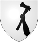
blason de la commune de Saint-Urcize : D'argent au dextrochère de sable , posé en pal à senestre et brandissant une hache du même, posée en barre.


