Saint-Vallier (Drôme)
| miejscowość i gmina | |||
 Saint-Vallier, 2008 | |||
| |||
| Państwo | |||
|---|---|---|---|
| Region | |||
| Departament | |||
| Okręg | |||
| Kod INSEE | 26333 | ||
| Powierzchnia | 5,42 km² | ||
| Populacja (1990) • liczba ludności |
| ||
| • gęstość | 759 os./km² | ||
| Kod pocztowy | 26240 | ||
Położenie na mapie Drôme  | |||
Położenie na mapie Francji  | |||
Położenie na mapie regionu Owernia-Rodan-Alpy  | |||
| Strona internetowa | |||
| Portal | |||
Saint-Vallier – miejscowość i gmina we Francji, w regionie Owernia-Rodan-Alpy, w departamencie Drôme.
Według danych na rok 1990 gminę zamieszkiwało 4115 osób, a gęstość zaludnienia wynosiła 759 osób/km² (wśród 2880 gmin regionu Rodan-Alpy Saint-Vallier plasuje się na 209. miejscu pod względem liczby ludności, natomiast pod względem powierzchni na miejscu 1484.).
Miasta partnerskie
Galeria

Dworzec kolejowy, 2011
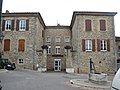
Plac, 2008

Kościół św. Walerego, 2008
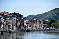
Wybrzeże Rodanu, 2016
Bibliografia
- Francuski urząd statystyczny (fr.).
Media użyte na tej stronie
Drome department location map.svg
Autor: Flappiefh, Licencja: CC BY-SA 4.0
Blank administrative map of the department of Drôme, France, for geo-location purpose.
Autor: Flappiefh, Licencja: CC BY-SA 4.0
Blank administrative map of the department of Drôme, France, for geo-location purpose.
France location map-Regions and departements-2016.svg
Autor: Superbenjamin, Licencja: CC BY-SA 4.0
Blank administrative map of France for geo-location purpose, with regions and departements distinguished. Approximate scale : 1:3,000,000
Autor: Superbenjamin, Licencja: CC BY-SA 4.0
Blank administrative map of France for geo-location purpose, with regions and departements distinguished. Approximate scale : 1:3,000,000
Auvergne-Rhône-Alpes region location map.svg
Autor: Flappiefh, Licencja: CC BY-SA 4.0
Carte administrative vierge de la région Auvergne-Rhône-Alpes, France, destinée à la géolocalisation.
Autor: Flappiefh, Licencja: CC BY-SA 4.0
Carte administrative vierge de la région Auvergne-Rhône-Alpes, France, destinée à la géolocalisation.
.svg)


St Vallier église.JPG
Autor: Gachepi, Licencja: CC BY-SA 3.0
église Saint Valéry de Saint-Vallier dans la Drôme
Autor: Gachepi, Licencja: CC BY-SA 3.0
église Saint Valéry de Saint-Vallier dans la Drôme

Coast of Rhône in Saint-Vallier 02.JPG
Autor: Krzysztof Golik, Licencja: CC BY-SA 4.0
Wybrzeże Rodanu w Saint-Vallier
Autor: Krzysztof Golik, Licencja: CC BY-SA 4.0
Wybrzeże Rodanu w Saint-Vallier

St Vallier place de la pompe.JPG
Autor: Gachepi, Licencja: CC BY-SA 3.0
place de la pompe à Saint-Vallier dans la Drôme
Autor: Gachepi, Licencja: CC BY-SA 3.0
place de la pompe à Saint-Vallier dans la Drôme

Saint-Vallier - gare.jpg
Autor: Peter Potrowl, Licencja: CC BY 3.0
The train station of Saint-Vallier (Drôme, France).
Autor: Peter Potrowl, Licencja: CC BY 3.0
The train station of Saint-Vallier (Drôme, France).
_1867.svg)