Saksonia-Weimar-Eisenach
| 1809–1918 | |||||
| |||||
 | |||||
| Stolica | |||||
|---|---|---|---|---|---|
| Ustrój polityczny | |||||
| Głowa państwa | wielki książę Wilhelm Ernest | ||||
| Powierzchnia • całkowita |
| ||||
| Liczba ludności (1910) • całkowita • gęstość zaludnienia |
| ||||
 | |||||
Księstwo Saksonii-Weimar-Eisenach, od 1815 Wielkie Księstwo Saksonii-Weimar-Eisenach (niem. Großherzogtum Sachsen-Weimar-Eisenach) – państwo niemieckie wywodzące się z księstwa Świętego Cesarstwa Rzymskiego Narodu Niemieckiego ernestyńskiej linii dynastii Wettynów, ze stolicą w Weimarze. Powstało w 1809 w wyniku połączenia przez księcia Karola Augusta księstw: Saksonii-Eisenach i Saksonii-Weimar.
Historia
W 1815 uzyskało status wielkiego księstwa. W tym samym roku weszło w skład Związku Niemieckiego, w 1866 roku w skład Związku Północnoniemieckiego; po zjednoczeniu Niemiec w 1871 roku zostało jednym z krajów Cesarstwa Niemieckiego.
W wyniku rewolucji listopadowej w 1918 i obaleniu monarchii państwo przekształcono w Wolne Państwo Saksonia-Weimar-Eisenach (Freistaat Sachsen-Weimar-Eisenach), które dwa lata później weszło w skład Turyngii.
Władcy
- 1809–1828 Karol August I (od 1815 wielki książę)
- 1828–1853 Karol Fryderyk (syn)
- 1853–1901 Karol Aleksander (syn)
- 1901–1918 Wilhelm Ernest (wnuk, usunięty, zm. 1923)
od 1918 republika
Tytularni wielcy książęta sascy na Weimarze i Eisenach:
- 1918–1923 Wilhelm Ernest
- 1923–1988 Karol August (1912–1988), syn
- 1988– : Michał (ur. 1946), syn
Przypisy
Media użyte na tej stronie
Flaga Niemiec o proporcjach 3:2
Flag of the duchy of Saxe-Coburg & Gotha 1911-1920; Ratio (2:3)
Flag of the Kingdom of Württemberg; Ratio (3:5)
Autor: ziegelbrenner, Licencja: CC BY 2.5
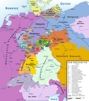
Map of Confederation of the Rhine 1812
Flag of the Grand Duchy of Baden 1855-1891; Ratio (3:5)
Flag of the duchy of Saxe-Coburg & Gotha 1826-1911; Ratio (2:3)
Flag of Alsace-Lorraine, adopted on the 25th of June 1912 and flag of the Republic of Alsace-Lorraine (Nov 11 1918 - Nov 21 1918)
Flag of the Duchy of Anhalt and also flag of Augsburg
Flag of the principality of Reuß Younger Line; Ratio (4:5) may also be (5:6)
Flag of the principality of Lippe; Ratio (2:3)
Flag of the Grand Duchies of Mecklenburg-Strelitz and Mecklenburg-Schwerin; Ratio (2:3)
Autor: Glasshouse using elements by Sodacan, Trondivers and katepanomegas, Licencja: CC BY-SA 4.0
Coat of Arms of the Grand Duchy of Saxe-Weimar-Eisenach
Albrecht I Bär
Autor: User:52 Pickup, Licencja: CC BY-SA 2.5
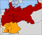
The North German Confederation / Norddeutscher Bund (1867–1871) in red. The states that would join the confederation and form the German Empire are in orange. Alsace-Lorraine, the territory annexed from France following the Franco-Prussian War of 1871, is in a paler orange.
Flag of the Grand Duchy of Saxe-Weimar-Eisenach 1813-1897; Ratio (2:3)
Flag of the principalities of Schwarzburg-Sondershausen and Schwarzburg-Rudolstadt; Ratio (2:3)
Flag of the Kingdom of Saxony; Ratio (2:3)
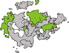
Karte Thüringen 1900 mit Herzogtum Sachsen-Weimar-Eisenach
Flag of the Grand Duchy of Hesse without arms; Ratio (4:5)
Civil flag of Oldenburg, before 1871 and beween 1921 and 1935
Flag of the principality of Schaumburg-Lippe; Ratio (2:3), c. 1880–1935
Flag of the duchy of Brunswick; Ratio (2:3)
Autor: Milenioscuro, Licencja: CC BY-SA 3.0
Locator map of Saxe-Weimar-Eisenach in the German Empire
Imperial Eagle of the German Empire from 1889 to 1918.
Flag of the principality of Reuss Elder Line; Ratio (27:34)


