Salisbury (dystrykt)
| dystrykt niemetropolitalny | |
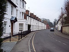
(c) Trish Steel, CC BY-SA 2.0 Wilton | |
| Państwo | |
|---|---|
| Kraj | |
| Region | South West England |
| Hrabstwo | Wiltshire |
| Populacja (2001) • liczba ludności | 114 613 |
Położenie na mapie Wiltshire | |
| Portal | |
Salisbury – były dystrykt w hrabstwie Wiltshire w Anglii. W 2001 roku dystrykt liczył 114 613 mieszkańców[1].
Civil parishes
- Alderbury, Allington, Alvediston, Amesbury, Ansty, Barford St. Martin, Berwick St. James, Berwick St. John, Berwick St. Leonard, Bishopstone, Bower Chalke, Britford, Broad Chalke, Bulford, Burcombe Without, Chicklade, Chilmark, Cholderton, Clarendon Park, Compton Chamberlayne, Coombe Bissett, Dinton, Donhead St. Andrew, Donhead St. Mary, Downton, Durnford, Durrington, East Knoyle, Ebbesborne Wake, Figheldean, Firsdown, Fonthill Bishop, Fonthill Gifford, Fovant, Great Wishford, Grimstead, Hindon, Idmiston, Kilmington, Landford, Laverstock, Maiden Bradley with Yarnfield, Mere, Milston, Netherhampton, Newton Tony, Odstock, Orcheston, Pitton and Farley, Quidhampton, Redlynch, Sedgehill and Semley, Shrewton, South Newton, Stapleford, Steeple Langford, Stourton with Gasper, Stratford Toney, Sutton Mandeville, Swallowcliffe, Teffont, Tilshead, Tisbury, Tollard Royal, West Dean, West Knoyle, West Tisbury, Whiteparish, Wilsford cum Lake, Wilton, Winterbourne, Winterbourne Stoke, Winterslow, Woodford, Wylye i Zeals[2].
Przypisy
- ↑ Neighbourhood Statistics
- ↑ w 2001. [dostęp 2016-01-15]. [zarchiwizowane z tego adresu (2016-10-21)].
Media użyte na tej stronie
Flag of England.svg
Flag of England. Saint George's cross (a red cross on a white background), used as the Flag of England, the Italian city of Genoa and various other places.
Flag of England. Saint George's cross (a red cross on a white background), used as the Flag of England, the Italian city of Genoa and various other places.
Russell Street, Wilton - geograph.org.uk - 330753.jpg
(c) Trish Steel, CC BY-SA 2.0
Russell Street, Wilton
(c) Trish Steel, CC BY-SA 2.0
Russell Street, Wilton


