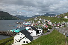
Saltangará
| ||
| Państwo | ||
| Terytorium zależne | ||
| Gmina | Runavíkar kommuna | |
| Populacja (I 2015) • liczba ludności | 977[1] | |
| Kod pocztowy | FO-600 | |
| Portal | ||
Saltangará (duń. Saltangerå) – miejscowość położona na Wyspach Owczych, na wyspie Eysturoy, mająca obecnie (I 2015 r.) 977 mieszkańców[1]. Kod pocztowy: FO-600.
Historia
Saltangará założono w roku 1846.
Demografia
Według danych Urzędu Statystycznego (I 2015 r.) jest dziesiątą co do wielkości miejscowością Wysp Owczych.
Ludność Saltangará w latach 1985-2015
Źródło: [1]
Przypisy
| ||||
Media użyte na tej stronie
Location of Runavíkar kommuna at the Faroe Islands, with borders as of 2009.
Autor: User:Erik Christensen, Licencja: CC-BY-SA-3.0
Toftir south of the Skálafjørður in Eysturoy, Faroe Islands
Autor: Erik Frohne, Licencja: CC BY-SA 3.0
Location map of the Faroe Islands
Equirectangular projection, N/S stretching 213 %. Geographic limits of the map:
- N: 62.44° N
- S: 61.30° N
- W: 7.88° W
- E: 6.00° W


