San Fernando Valley
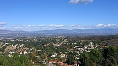
Widok doliny San Fernando z północnej grani Gór Santa Monica | |
| Państwo | |
|---|---|
| Stan | |
| Powierzchnia | 582 km² |
| Populacja (2000) • liczba ludności |
|
| • gęstość | 2469 os./km² |
| Szczegółowy podział administracyjny | |
| Liczba miast | 6 |
| Liczba obszarów niemunicypalnych | 5 |
| Liczba dzielnic | 38 |
Położenie na mapie | |
| 34°14′18,55″N 118°27′46,19″W/34,238486 -118,462831 | |
| Portal | |
San Fernando Valley – zurbanizowana dolina położona w hrabstwie Los Angeles, w południowej Kalifornii, pośrodku otaczającego ją pasma górskiego Transverse Ranges. Prawie dwie trzecie powierzchni doliny leży w obrębie Los Angeles. W pozostałej części doliny leżą miasta Glendale, Burbank, San Fernando, Hidden Hills i Calabasas będące częścią aglomeracji Los Angeles.
Położenie
Dolina otoczona od północnego zachodu górami Santa Susana, wzgórzami Simi Hills od zachodu, od południa górami Santa Monica i wzgórzami Chalk Hills, małym pasmem górskim Verdugo od wschodu i górami San Gabriel na północnym wschodzie.
Gminy i dystrykty
Miasta włączone (niezależne)
Obszary niemunicypalne
- Bell Canyon
- Calabasas Highlands
- Kagel Canyon
- Universal City
- West Chatsworth
Dzielnice
- Arleta
- Cahuenga Pass
- Canoga Park
- Chatsworth
- Colfax Meadows
- Encino
- Granada Hills
- Kagel Canyon
- La Tuna Canyon
- Lake Balboa
- Lake View Terrace
- Mission Hills
- NoHo Arts District
- North Hills
- North Hollywood
- Northridge
- Pacoima
- Panorama City
- Porter Ranch
- Reseda
- Shadow Hills
- Sherman Oaks
- Stonehurst
- Studio City
- Sun Valley
- Sunland-Tujunga
- Sylmar
- Tarzana
- Toluca Lake
- Toluca Woods
- Valley Glen
- Valley Village
- Van Nuys
- Warner Center
- West Hills
- West Toluca
- Winnetka
- Woodland Hills
Bibliografia
- San Fernando Valley Statistics and Facts. library.csun.edu. [zarchiwizowane z tego adresu (2015-09-05)].
Przypisy
- ↑ The San Fernando Valley (ang.). [dostęp 2015-10-31].
Media użyte na tej stronie
The flag of Navassa Island is simply the United States flag. It does not have a "local" flag or "unofficial" flag; it is an uninhabited island. The version with a profile view was based on Flags of the World and as a fictional design has no status warranting a place on any Wiki. It was made up by a random person with no connection to the island, it has never flown on the island, and it has never received any sort of recognition or validation by any authority. The person quoted on that page has no authority to bestow a flag, "unofficial" or otherwise, on the island.
Flag of California. This version is designed to accurately depict the standard print of the bear as well as adhere to the official flag code regarding the size, position and proportion of the bear, the colors of the flag, and the position and size of the star.
Autor: Matthew Trump, Licencja: CC-BY-SA-3.0
Greater en:Los Angeles Basin
(c) Oakshade z angielskiej Wikipedii, CC-BY-SA-3.0
View of the San Fernando Valley from northern edge of the Santa Monica Mountains above Woodland Hills, Los Angeles.
- The San Gabriel Mountains are in the distant background.
3-D Perspective image of the Los Angeles Basin from the Landsat satellite using NASA's Shuttle Radar Topography Mission (SRTM) for topography information. The vertical scale is exaggerated one and half times.
Autor: Tom Adams from Austin, USA, Licencja: CC BY-SA 2.0
A panorama from the roof of a parking garage at Universal Studios Hollywood overlooking the San Fernando Valley and Burbank. You can see part of the Universal City back lot in the foreground.


