San Marcos (Teksas)
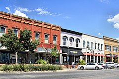
(c) Larry D. Moore, CC BY-SA 3.0 Historyczna dzielnica San Marcos. | |
| Przydomek: San Marvelous | |
| Państwo | |
|---|---|
| Stan | |
| Hrabstwo | |
| Powierzchnia | 92,5 km² |
| Wysokość | 188 m n.p.m. |
| Populacja (2020) • liczba ludności • gęstość |
|
| Nr kierunkowy | 512 |
| Kod pocztowy | 78666-78667 |
| Strona internetowa | |
| Portal | |
San Marcos – miasto w Stanach Zjednoczonych, w stanie Teksas, w hrabstwach Hays, Caldwell i Guadalupe. Według spisu w 2020 roku liczy 67,6 tys. mieszkańców, co oznacza, że w ciągu ostatnich 25 lat populacja miasta podwoiła się. Ponad 40% populacji to Latynosi[1][2]. Należy do obszaru metropolitalnego Austin.
Jest siedzibą Texas State University, który jest piątym co do wielkości uniwersytetem w Teksasie i mieści Centrum Antropologii Sądowej w stanie Teksas, które jest największym ośrodkiem badawczym medycyny sądowej na świecie[2].
Przez park miejski przepływa rzeka San Marcos, stwarzając rekreacyjne możliwości pływania, nurkowania, czy wiosłowania[3]. Ten uniwersytecki obszar uznawany jest za jeden z najstarszych, nieprzerwanie zamieszkałych miejsc w Ameryce[2].
Przypisy
- ↑ U.S. Census Bureau QuickFacts: San Marcos city, Texas, www.census.gov [dostęp 2022-06-05] (ang.).
- ↑ a b c San Marcos: You Better Get Here Before Everyone Else Does, Texas Hill Country, 28 sierpnia 2017 [dostęp 2022-06-05] (ang.).
- ↑ Plan a Trip to Galveston and Experience the Beauty of the Texas Coast, Southern Living [dostęp 2022-06-05] (ang.).
Media użyte na tej stronie
Autor: Alexrk, Licencja: CC BY 3.0
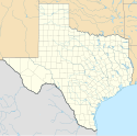
Ta mapa została stworzona za pomocą GeoTools.
Autor: Uwe Dedering, Licencja: CC BY-SA 3.0
Location map of the USA (without Hawaii and Alaska).
EquiDistantConicProjection:
Central parallel:
* N: 37.0° N
Central meridian:
* E: 96.0° W
Standard parallels:
* 1: 32.0° N
* 2: 42.0° N
Made with Natural Earth. Free vector and raster map data @ naturalearthdata.com.
Formulas for x and y:
x = 50.0 + 124.03149777329222 * ((1.9694462586094064-({{{2}}}* pi / 180))
      * sin(0.6010514667026994 * ({{{3}}} + 96) * pi / 180))
y = 50.0 + 1.6155950752393982 * 124.03149777329222 * 0.02613325650382181
      - 1.6155950752393982  * 124.03149777329222 *
     (1.3236744353715044  - (1.9694462586094064-({{{2}}}* pi / 180))
      * cos(0.6010514667026994 * ({{{3}}} + 96) * pi / 180))
The flag of Navassa Island is simply the United States flag. It does not have a "local" flag or "unofficial" flag; it is an uninhabited island. The version with a profile view was based on Flags of the World and as a fictional design has no status warranting a place on any Wiki. It was made up by a random person with no connection to the island, it has never flown on the island, and it has never received any sort of recognition or validation by any authority. The person quoted on that page has no authority to bestow a flag, "unofficial" or otherwise, on the island.
(c) Larry D. Moore, CC BY-SA 3.0
The Hays County Courthouse Historic District in San Marcos, Texas, United States. The district was listed on the National Register of Historic Places on August 26, 1983.


