Sandy Springs
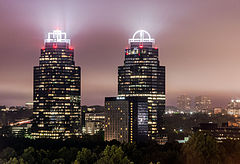
 Współczesna panorama Sandy Springs jest zdominowana przez biurowce Concourse. | |
| Państwo | |
|---|---|
| Stan | |
| Hrabstwo | |
| Kod statystyczny | |
| Zarządzający | Rusty Paul↗ |
| Powierzchnia | 99,8 km² |
| Wysokość | 333 m n.p.m. |
| Populacja (2020) • liczba ludności • gęstość |
|
| Nr kierunkowy | 404, 470, 678, 770 |
| Kod pocztowy | 30328, 30327, 30338, 30342, 30350, 30358[1] |
| Strefa czasowa | |
| Strona internetowa | |
| Portal | |
Sandy Springs – miasto w Stanach Zjednoczonych, w stanie Georgia, w hrabstwie Fulton. Jest jednym z głównych miast obszaru metropolitalnego Atlanty, położonym na północ od Atlanty i na południe od Roswell[2]. Według spisu powszechnego w 2020 roku liczy 108,1 tys. mieszkańców[3].
Demografia
Miasto posiada stosunkowo małą populację Afroamerykanów (19,6%), a większość stanowią osoby białe nielatynoskie (58,4%). Populacja Latynosów (12,2%) jest nieco większa i Azjatów (7,2%) porównywalna do średniej hrabstwa Fulton[3]. 2,5% osób deklaruje polskie pochodzenie[4].
Przypisy
- ↑ Look Up a ZIP Code (ang.). United States Postal Service. [dostęp 2011-11-08].
- ↑ Sandy Springs Neighborhoods, Sandy Springs [dostęp 2022-07-18] (ang.).
- ↑ a b U.S. Census Bureau QuickFacts: Fulton County, Georgia; Sandy Springs city, Georgia; Georgia, www.census.gov [dostęp 2022-07-18] (ang.).
- ↑ 2020: ACS 5-Year Estimates Data Profiles, data.census.gov [dostęp 2022-08-26].
Media użyte na tej stronie
Autor: Uwe Dedering, Licencja: CC BY-SA 3.0
Location map of the USA (without Hawaii and Alaska).
EquiDistantConicProjection:
Central parallel:
* N: 37.0° N
Central meridian:
* E: 96.0° W
Standard parallels:
* 1: 32.0° N
* 2: 42.0° N
Made with Natural Earth. Free vector and raster map data @ naturalearthdata.com.
Formulas for x and y:
x = 50.0 + 124.03149777329222 * ((1.9694462586094064-({{{2}}}* pi / 180))
      * sin(0.6010514667026994 * ({{{3}}} + 96) * pi / 180))
y = 50.0 + 1.6155950752393982 * 124.03149777329222 * 0.02613325650382181
      - 1.6155950752393982  * 124.03149777329222 *
     (1.3236744353715044  - (1.9694462586094064-({{{2}}}* pi / 180))
      * cos(0.6010514667026994 * ({{{3}}} + 96) * pi / 180))
The flag of Navassa Island is simply the United States flag. It does not have a "local" flag or "unofficial" flag; it is an uninhabited island. The version with a profile view was based on Flags of the World and as a fictional design has no status warranting a place on any Wiki. It was made up by a random person with no connection to the island, it has never flown on the island, and it has never received any sort of recognition or validation by any authority. The person quoted on that page has no authority to bestow a flag, "unofficial" or otherwise, on the island.
Autor: Maksim Sundukov, Licencja: CC BY-SA 3.0
Concourse Corporate Center V and VI, but are known locally as "the King and Queen towers" at night. Atlanta, GA, USA.
Autor: Alexrk2, Licencja: CC BY 3.0
Ta mapa została stworzona za pomocą GeoTools.


