Santa Barbara Island
 Santa Barbara Island | |
| Kontynent | |
|---|---|
| Państwo | |
| Akwen | |
| Archipelag | |
| Powierzchnia | 2,6 km² |
Położenie na mapie Kalifornii  | |
Położenie na mapie Stanów Zjednoczonych  | |
 | |
Santa Barbara Island – mała wyspa archipelagu Channel Islands w Kalifornii, w Stanach Zjednoczonych.
Wyspa leży około 60 km od półwyspu Palos Verdes w hrabstwie Ventura, niedaleko Los Angeles[1], jej łączna powierzchnia wynosi około 2,6 km², jest najmniejszą z ośmiu wysp archipelagu Channel Islands i zarazem najbardziej wysuniętą na południe wyspą Parku Narodowego Channel Islands. Najwyższym szczytem na wyspie jest Signal Hill (193 m).
Geologia, fauna i flora
Pomimo tego, że wyspa nie jest wulkanem składa się głównie z mioceńskich skał wulkanicznych (głównie bazaltu) i osadów morskich. W pobliżu wyspy leżą dwie skały: Shag Rock (0,004 km²) i Sutil Island (0,049 km²).
Na wyspie znajduje się duża kolonia lwów morskich i kolonie lęgowe ptaków morskich, m.in. zagrożonego gatunku Murrelet Xantus.
Dudleya traskiae to rzadki, endemiczny sukulent rosnący na wyspie, znany pod nazwą Santa Barbara Island liveforever.
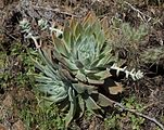
Dudleya traskiae

Zobacz też
Przypisy
- ↑ Santa Barbara Island. [dostęp 2013-01-08]. (ang.).
Bibliografia
Linki zewnętrzne
- Island Packers. islandpackers.com. [zarchiwizowane z tego adresu (2013-01-26)].

| Wyspy północne |
|
|---|---|
| Wyspy południowe |
|

Media użyte na tej stronie
Autor: Uwe Dedering, Licencja: CC BY-SA 3.0
Relief location map of the USA (without Hawaii and Alaska).
EquiDistantConicProjection : Central parallel :
* N: 37.0° N
Central meridian :
* E: 96.0° W
Standard parallels:
* 1: 32.0° N
* 2: 42.0° N
Made with Natural Earth. Free vector and raster map data @ naturalearthdata.com.
Formulas for x and y:
x = 50.0 + 124.03149777329222 * ((1.9694462586094064-({{{2}}}* pi / 180))
      * sin(0.6010514667026994 * ({{{3}}} + 96) * pi / 180))
y = 50.0 + 1.6155950752393982 * 124.03149777329222 * 0.02613325650382181
      - 1.6155950752393982  * 124.03149777329222 *
     (1.3236744353715044  - (1.9694462586094064-({{{2}}}* pi / 180))
      * cos(0.6010514667026994 * ({{{3}}} + 96) * pi / 180))

The flag of Navassa Island is simply the United States flag. It does not have a "local" flag or "unofficial" flag; it is an uninhabited island. The version with a profile view was based on Flags of the World and as a fictional design has no status warranting a place on any Wiki. It was made up by a random person with no connection to the island, it has never flown on the island, and it has never received any sort of recognition or validation by any authority. The person quoted on that page has no authority to bestow a flag, "unofficial" or otherwise, on the island.

Autor: Lencer, Licencja: CC BY-SA 3.0
Map of the Channel Islands archipelago — in Southern California.
- The northern islands (dark green) are protected within Channel Islands National Park.
- The marine ecosystem around the northern islands and Santa Barbara Island is protected within the Channel Islands National Marine Sanctuary.
- Depending on location — islands are within either Los Angeles County, Ventura County, or Santa Barbara County.
Flag of California. This version is designed to accurately depict the standard print of the bear as well as adhere to the official flag code regarding the size, position and proportion of the bear, the colors of the flag, and the position and size of the star.
