Santa Clara (Kalifornia)
| ||||
| ||||
| Państwo | ||||
|---|---|---|---|---|
| Stan | ||||
| Hrabstwo | ||||
| Kod statystyczny | ||||
| Burmistrz | Lisa Gillmor | |||
| Powierzchnia | 47,675 km² | |||
| Wysokość | 23 m n.p.m. | |||
| Populacja (2010) • liczba ludności • gęstość |
| |||
| Nr kierunkowy | 408 | |||
| Kod pocztowy | 95050-95056 | |||
| Strefa czasowa | ||||
| Strona internetowa | ||||
| Portal | ||||
Santa Clara – miasto w Stanach Zjednoczonych, w stanie Kalifornia, w aglomeracji San Jose w Dolinie Krzemowej.
W mieście znajduje się główna siedziba firmy Nvidia, a także Intel i Sun Microsystems. Liczba mieszkańców w 2012 roku według szacunków US Census Bureau wyniosła 119 311 osób[1].
Miasta partnerskie
Przypisy
- ↑ State & County QuickFacts, Santa Clara (city), California (ang.). US Census Bureau. [dostęp 2013-12-28].
Media użyte na tej stronie
Autor: Uwe Dedering, Licencja: CC BY-SA 3.0
Location map of the USA (without Hawaii and Alaska).
EquiDistantConicProjection:
Central parallel:
* N: 37.0° N
Central meridian:
* E: 96.0° W
Standard parallels:
* 1: 32.0° N
* 2: 42.0° N
Made with Natural Earth. Free vector and raster map data @ naturalearthdata.com.
Formulas for x and y:
x = 50.0 + 124.03149777329222 * ((1.9694462586094064-({{{2}}}* pi / 180))
      * sin(0.6010514667026994 * ({{{3}}} + 96) * pi / 180))
y = 50.0 + 1.6155950752393982 * 124.03149777329222 * 0.02613325650382181
      - 1.6155950752393982  * 124.03149777329222 *
     (1.3236744353715044  - (1.9694462586094064-({{{2}}}* pi / 180))
      * cos(0.6010514667026994 * ({{{3}}} + 96) * pi / 180))
The flag of Navassa Island is simply the United States flag. It does not have a "local" flag or "unofficial" flag; it is an uninhabited island. The version with a profile view was based on Flags of the World and as a fictional design has no status warranting a place on any Wiki. It was made up by a random person with no connection to the island, it has never flown on the island, and it has never received any sort of recognition or validation by any authority. The person quoted on that page has no authority to bestow a flag, "unofficial" or otherwise, on the island.
Flag of Portugal, created by Columbano Bordalo Pinheiro (1857-1929), officially adopted by Portuguese government in June 30th 1911 (in use since about November 1910). Color shades matching the RGB values officially reccomended here. (PMS values should be used for direct ink or textile; CMYK for 4-color offset printing on paper; this is an image for screen display, RGB should be used.)
The official city flag of Santa Clara, California, first created in 1967.
(c) Coolcaesar at the English Wikipedia, CC-BY-SA-3.0
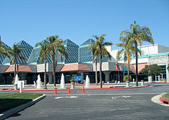
The Santa Clara Convention Center in Santa Clara. Photographed by user Coolcaesar on July 28, 2007.
Flag of California. This version is designed to accurately depict the standard print of the bear as well as adhere to the official flag code regarding the size, position and proportion of the bear, the colors of the flag, and the position and size of the star.
Autor: User Coolcaesar on en.wikipedia, Licencja: CC-BY-SA-3.0
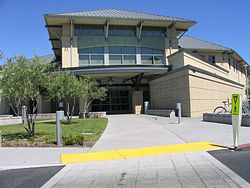
The Central Park Library in en:Santa Clara, California.
Autor: NordNordWest, Licencja: CC BY 3.0
Location map of California, USA


