Santa Cruz (góry)
 Winnice w górach Santa Cruz | |
| Kontynent | |
|---|---|
| Państwo | |
| Stan | |
| Najwyższy szczyt | Loma Prieta |
| 37,1108°N 121,8450°W/37,110800 -121,845000 | |
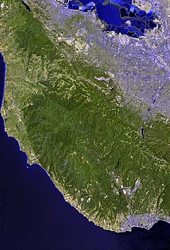
Santa Cruz (Santa Cruz Mountains) – pasmo górskie w Stanach Zjednoczonych, w zachodniej Kalifornii, na obszarze hrabstw Santa Clara, Santa Cruz oraz San Mateo[1], stanowiące część pasma Gór Nadbrzeżnych. Góry położone są częściowo na terenie półwyspu San Francisco i rozciągają się wzdłuż wybrzeża Oceanu Spokojnego, na zachód i południe od zatoki San Francisco.
Najwyższym wzniesieniem w paśmie jest Loma Prieta (1148 m n.p.m.)[1].
Główne miasta położone w sąsiedztwie gór Santa Cruz to San Jose na wschodzie oraz San Francisco na północy.
Od połowy XIX wieku na terenie gór prowadzona jest uprawa winorośli[2].
Przypisy
Media użyte na tej stronie
Autor: Uwe Dedering, Licencja: CC BY-SA 3.0
Relief location map of the USA (without Hawaii and Alaska).
EquiDistantConicProjection : Central parallel :
* N: 37.0° N
Central meridian :
* E: 96.0° W
Standard parallels:
* 1: 32.0° N
* 2: 42.0° N
Made with Natural Earth. Free vector and raster map data @ naturalearthdata.com.
Formulas for x and y:
x = 50.0 + 124.03149777329222 * ((1.9694462586094064-({{{2}}}* pi / 180))
      * sin(0.6010514667026994 * ({{{3}}} + 96) * pi / 180))
y = 50.0 + 1.6155950752393982 * 124.03149777329222 * 0.02613325650382181
      - 1.6155950752393982  * 124.03149777329222 *
     (1.3236744353715044  - (1.9694462586094064-({{{2}}}* pi / 180))
      * cos(0.6010514667026994 * ({{{3}}} + 96) * pi / 180))
The flag of Navassa Island is simply the United States flag. It does not have a "local" flag or "unofficial" flag; it is an uninhabited island. The version with a profile view was based on Flags of the World and as a fictional design has no status warranting a place on any Wiki. It was made up by a random person with no connection to the island, it has never flown on the island, and it has never received any sort of recognition or validation by any authority. The person quoted on that page has no authority to bestow a flag, "unofficial" or otherwise, on the island.
Flag of California. This version is designed to accurately depict the standard print of the bear as well as adhere to the official flag code regarding the size, position and proportion of the bear, the colors of the flag, and the position and size of the star.
Black up-pointing triangle ▲, U+25B2 from Unicode-Block Geometric Shapes (25A0–25FF)
Autor: http://www.terraprints.com, Licencja: CC BY 2.5
Aerial view of the Category:Santa Cruz Mountains - in northern California].
- The raw satellite imagery shown in these images was obtained from NASA and/or the US Geological Survey.
- Post-processing and production by http://www.terraprints.com .
Autor: John, Licencja: CC BY-SA 2.0
View of the Santa Cruz Mountain AVA from the California winery Ridge Vineyards.


