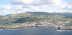
Santa Cruz da Graciosa
| gmina | |||||
 | |||||
| Państwo | |||||
|---|---|---|---|---|---|
| Region (NUTS 2) | |||||
| Powierzchnia | 60,7 km² | ||||
| Populacja (2011) • liczba ludności |
| ||||
| • gęstość | 72,3 os./km² | ||||
| Szczegółowy podział administracyjny | |||||
| Liczba sołectw | 4 | ||||
Położenie na mapie Azorów | |||||
| 39°03′17″N 28°00′51″W/39,054722 -28,014167 | |||||
| Strona internetowa | |||||
Santa Cruz da Graciosa − miasto i gmina (port. concelho) na Azorach (region autonomiczny Portugalii), na wyspie Graciosa. Według danych szacunkowych na rok 2011 liczy 4391 mieszkańców.
Podział administracyjny
Gmina ta dzieli się na 4 sołectwa (ludność wg stanu na 2011 r.)[1]
- Santa Cruz da Graciosa – 1776 osób
- Guadalupe – 1096 osób
- Praia (São Mateus) – 836 osób
- Luz – 683 osoby
Przypisy
- ↑ Statistics Portugal, www.ine.pt [dostęp 2018-02-11] (ang.).
Media użyte na tej stronie
Flag of Portugal, created by Columbano Bordalo Pinheiro (1857-1929), officially adopted by Portuguese government in June 30th 1911 (in use since about November 1910). Color shades matching the RGB values officially reccomended here. (PMS values should be used for direct ink or textile; CMYK for 4-color offset printing on paper; this is an image for screen display, RGB should be used.)
Autor: Jorge Candeias, original map by António Martins., Licencja: CC-BY-SA-3.0
Map of the Azores highlighting Santa Cruz da Graciosa.
Santa Cruz da Graciosa, Azores, seen from a plane. At the center the Monte da Ajuda.


