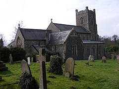
Saxmundham
(c) Adrian Cable, CC BY-SA 2.0 | |
| Państwo | |
|---|---|
| Kraj | |
| Region | East of England |
| Hrabstwo | Suffolk |
| Dystrykt | Suffolk Coastal |
| Populacja (2011) • liczba ludności | 3644 |
| Nr kierunkowy | 01728 |
| Kod pocztowy | IP17 |
Położenie na mapie Suffolk Contains Ordnance Survey data © Crown copyright and database right, CC BY-SA 3.0 | |
Położenie na mapie Wielkiej Brytanii (c) Karte: NordNordWest, Lizenz: Creative Commons by-sa-3.0 de | |
| Strona internetowa | |
| Portal | |
Saxmundham - miasto i civil parish w Wielkiej Brytanii, w Anglii, w hrabstwie Suffolk, w dystrykcie Suffolk Coastal[1]. W 2011 roku civil parish liczyła 3644 mieszkańców[2]. Saxmundham jest wspomniana w Domesday Book (1086) jako Samundeham/Sasmunde(s)ham/Saxmondeham[3].
Przypisy
- ↑ Ordnance Survey linked data
- ↑ Neighbourhood Statistics. [dostęp 2015-09-25]. [zarchiwizowane z tego adresu (2015-09-26)].
- ↑ The Domesday Book online
Media użyte na tej stronie
(c) Karte: NordNordWest, Lizenz: Creative Commons by-sa-3.0 de
Location map of the United Kingdom
Flag of England. Saint George's cross (a red cross on a white background), used as the Flag of England, the Italian city of Genoa and various other places.
Contains Ordnance Survey data © Crown copyright and database right, CC BY-SA 3.0
Map of Suffolk, UK with the following information shown:
- Administrative borders
- Coastline, lakes and rivers
- Roads and railways
- Urban areas
Equirectangular map projection on WGS 84 datum, with N/S stretched 160%
Geographic limits:
- West: 0.30E
- East: 1.90E
- North: 52.57N
- South: 51.92N
(c) Adrian Cable, CC BY-SA 2.0
St.John the Baptist Church, Saxmundham, Suffolk. For more information, go to http://www.saxmundham.org/aboutsax/parishchurch.html


