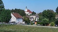
Schiedlberg
| |||
 | |||
| |||
| Państwo | |||
| Kraj związkowy | |||
| Powiat | Steyr-Land | ||
| Powierzchnia | 30,01 km² | ||
| Wysokość | 377 m n.p.m. | ||
| Populacja (1 stycznia 2015) • liczba ludności | 1214 | ||
| • gęstość | 40 os./km² | ||
| Numer kierunkowy | 07251 | ||
| Kod pocztowy | 4521 | ||
| Tablice rejestracyjne | SE | ||
| Strona internetowa | |||
Schiedlberg – gmina w Austrii, w kraju związkowym Górna Austria, w powiecie Steyr-Land, a według Austriackiego Urzędu Statystycznego liczyła 1214 mieszkańców (1 stycznia 2015)[1].
Przypisy
Media użyte na tej stronie
Autor: Lencer, Licencja: CC BY-SA 3.0
Location map of Austria
Equirectangular projection, N/S stretching 150 %. Geographic limits of the map:
- N: 49.2° N
- S: 46.3° N
- W: 9.4° E
- E: 17.2° E
Autor: Isiwal, Licencja: CC BY-SA 4.0
View on village Schiedlberg with parish church of the annunciation of Mary, Upper Austria
Autor: Rosso Robot, Licencja: CC BY-SA 3.0
Location map of Upper Austria
Equirectangular projection. Geographic limits of the map:
- N: 48.78063° N
- S: 47.44388° N
- W: 12.73041° E
- E: 15.00183° E


